Cof Cymru: National Historic Assets of Wales · Wales
3 Pwll-y-Min Crescent
Peterston-super-Ely, Vale of Glamorgan, Wales
A Grade II listed building in Wyndham Park, Peterston-super-Ely, Vale of Glamorgan, designated on 17 September 2002.
The record
- Designation
- Listed building, Grade II
- Broad class
- Domestic
- Date of designation
- 17 September 2002
- Locality
- Wyndham Park
- Community
- Peterston-super-Ely
- Unitary authority
- Vale of Glamorgan
- Country
- Wales
- Coordinates
- 51.47583, -3.31972
- Cadw reference
- 26950
Slide toward Today to fade the historical sheet and see the modern map underneath.
David Rumsey Map Collection, Stanford LibrariesDavid Rumsey Map Collection, Stanford LibrariesDavid Rumsey Map Collection, Stanford LibrariesDavid Rumsey Map Collection, Stanford LibrariesDavid Rumsey Map Collection, Stanford Libraries
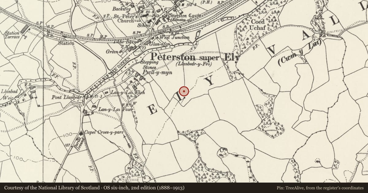
5 historical maps cover this location, the earliest the 1636 map "Cornubia : Devonia, Somersetus, Dorcestria, Wiltonia, Glocestria ..." (David Rumsey Map Collection, Stanford Libraries).
Historical maps covering this location
- 1636 · Cornubia : Devonia, Somersetus, Dorcestria, Wiltonia, Glocestria ... (David Rumsey Map Collection, Stanford Libraries)
- 1637 · The fourth table of England. Cornub. Devonia, Somerset etc. (David Rumsey Map Collection, Stanford Libraries)
- 1865 · England and Wales. England No. 6. (David Rumsey Map Collection, Stanford Libraries)
- 1898 · 263 Cardiff (Hills) (David Rumsey Map Collection, Stanford Libraries)
- 1913 · Sheet 110. Cardiff & Mouth of the Severn. (David Rumsey Map Collection, Stanford Libraries)
Cadw's description
Location
Wyndham Park is about 500m S of Peterston, on S side of River Ely. Pwll-y-Min Crescent is on N side of the main avenue, this range is on the upper slope.
History
A very large garden village development (Glyn Cory) on behalf of J & R Cory, the coal magnates, was proposed. A prospectus, and a brochure (both of 1909), describe proposals for a development of 1400 houses (5000-6000 inhabitants), some for sale, some for rent. A plan by Thomas Adams and Thomas Mawson projects a grand amphitheatre of concentric roads with radial avenues. The literature has designs for several conventional semi-detached houses by Speir & Bevan, architects, of Cardiff, a few of which were built in Cory Crescent, also Dyffryn Crescent. By 1914 no more than 22 houses had been built.
The unusual terrace of 10 houses in Pwll-y-Min Crescent does not appear in the electoral registers before the First World War (but registers were not compiled during the war). It is shown as complete on the Ordnance Survey map of 1919. The architect is currently not known, Unwin has suggested Thomas Adams, G Darley (cited by Unwin) has suggested the involvement in Glyn Cory of Baillie-Scott.
Exterior
No 3 has plastic windows and replaced door.
Reason for designation
Listed for its architectural interest as part of a most unusual crescent of early C20 houses, of strikingly original design.
Nearby in the register
- 4 Pwll-y-Min CrescentDomesticunder 1 mi
- 2 Pwll-y-Min CrescentDomesticunder 1 mi
- 5 Pwll-y-Min CrescentDomesticunder 1 mi
- 1 Pwll-y-Min CrescentDomesticunder 1 mi
Other entries of the same register within about three miles of this one, by straight line.