Cof Cymru: National Historic Assets of Wales · Wales
Candy Mill with Miller's Cottage and Leat
Aberwheeler, Denbighshire, Wales
A Grade II* listed building in Candy Mill, Aberwheeler, Denbighshire, designated on 20 May 2002.
The record
- Designation
- Listed building, Grade II*
- Broad class
- Industrial
- Date of designation
- 20 May 2002
- Locality
- Candy Mill
- Community
- Aberwheeler
- Unitary authority
- Denbighshire
- Country
- Wales
- Coordinates
- 53.23405, -3.33743
- Cadw reference
- 26643
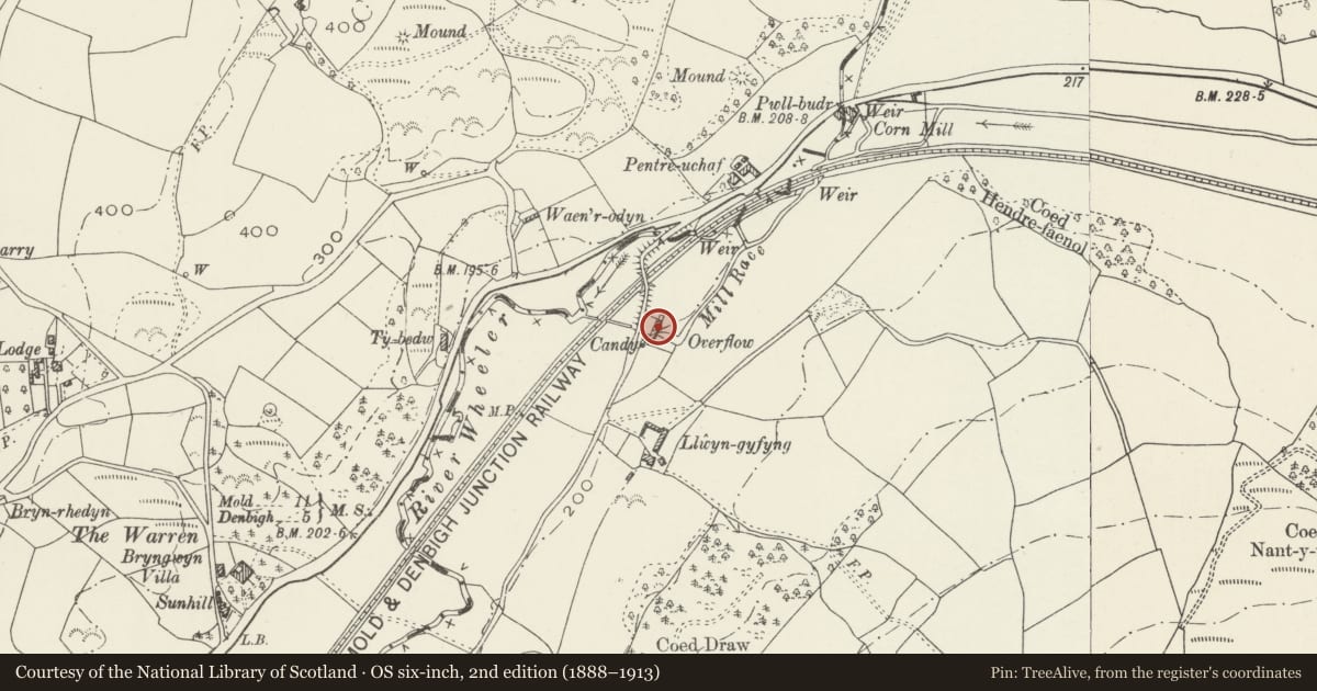
Slide toward Today to fade the historical sheet and see the modern map underneath.
David Rumsey Map Collection, Stanford LibrariesDavid Rumsey Map Collection, Stanford LibrariesDavid Rumsey Map Collection, Stanford LibrariesLlyfrgell Genedlaethol Cymru – The National Library of WalesDavid Rumsey Map Collection, Stanford Libraries
5 historical maps cover this location, the earliest the 1795 map "To Sir Watkin Williams-Wynn Bart ... the map of the six counties of North Wales is most humbly inscribed by his obedient humble servant" (Llyfrgell Genedlaethol Cymru – The National Library of Wales).
Historical maps covering this location
- 1795 · To Sir Watkin Williams-Wynn Bart ... the map of the six counties of North Wales is most… (Llyfrgell Genedlaethol Cymru – The National Library of Wales)
- 1830 · V.3:11-15:XV. Britisches Reich. A. Kon: England. b. Frstenthum Wales: Shire: 37-40 (David Rumsey Map Collection, Stanford Libraries)
- 1883 · Watershed map England, Wales 3. (David Rumsey Map Collection, Stanford Libraries)
- 1898 · 108 Flint (Hills) (David Rumsey Map Collection, Stanford Libraries)
- 1901 · Sheet 9 and 10. (David Rumsey Map Collection, Stanford Libraries)
Cadw's description
Location
To east of the River Aberwheeler near Ty Draw farm, reached by a minor road from the A541. Leat from the river about 400 m to the north feeding a small pond to its east, the tailwater carried back to the river by an underground culvert to the west.
History
Probably C18 or early C19. The mill was recorded in 1842 as Candy Mill, on the Dinorben estate, tenanted by William Williams, with 3 acres (1.2 hectares) including a meadow above the mill and a small pasture below. The last miller in c.1950 was also a Mr Williams.
Candy Mill has additional importance as a very rare survival of a clover mill, one of only a few in Britain and probably the last in Wales. (The type was described by Davies in use in South Wales in 1815.)
Exterior
A mill in uncoursed axe-dressed local limestone masonry with attached miller's house, the house retaining its slate roof but the mill roof now sheeted. The mill is of two storeys and its wheel is positioned internally at the centre. The headwater from the River Wheeler was collected in a small reservoir adjacent to the mill on the east side (now dry) and was passed to a tailwater culvert on the west.
The mill excluding the house consists of three sections; seen from the road, at left is a stable with a hayloft above, separated by a dividing wall from the rest of the mill. This is followed by loading doors aligned verically and the clover mill also with hayloft above. To the right, after the wheel position, is the corn mill on two storeys. In addition to the loading doors there are four hatches above, a stable door at left, three ground-storey windows centrally, and the entrance door to the mill at right. At the north end of the mill is a single storey later extension containing a further stable and cartshed. Another shed is attached to the rear.
The miller's house is to the right, separated by a full height wall. It has a two-window front elevation, with its door at left. Four-pane sash windows, modern door with overlight. Two window rear elevation also, with lean-to kitchen partly overlapping the mill.
Interior
At the centre of the mill is a large undershot composite wheel (approx. 7 m diameter by 2 m wide) with complete gearing and belting to all the machinery. The corn section of the mill to the south of the wheel is complete with two pairs of (Anglesey?) wheat stones; there is also a pair of (French burr?) stones for oats. Flour cleaning and grading machine below. At the other side of the wheel (to the north) is a clover mill. This is a single mill with a stock resembling the hub of a cartwheel but set vertically with spokes and beaters at regular distances around it.
A low opening in the south end wall of the mill (now walled up) gave access between the mill and the house. In the house it was located beneath the stairs. The house has two rooms below and three bedrooms, plus a kitchen in the lean-to extension at rear. Stone floor. Stairs against mill wall.
Reason for designation
Listed as an unusually intact corn mill with its machinery, including a clover mill; also a fine grouping of mill, house and outbuildings forming an unusually complete establishment.
Nearby in the register
- Bakehouse and Pigsties at Candy MillDomesticunder 1 mi
- Round Barrow 135m SE of Lodge FarmRound Barrowunder 1 mi
- Adwy-wyntDomesticunder 1 mi
- Moel y GaerHillfortunder 1 mi
Other entries of the same register within about three miles of this one, by straight line.