Cof Cymru: National Historic Assets of Wales · Wales
The Rest
Llanboidy, Carmarthenshire, Wales
A Grade II listed building in Crosshands, Whitland, Llanboidy, Carmarthenshire, designated on 6 August 2001.
The record
- Designation
- Listed building, Grade II
- Broad class
- Domestic
- Date of designation
- 6 August 2001
- Locality
- Crosshands
- Town
- Whitland
- Community
- Llanboidy
- Unitary authority
- Carmarthenshire
- Country
- Wales
- Coordinates
- 51.86993, -4.63515
- Cadw reference
- 25649
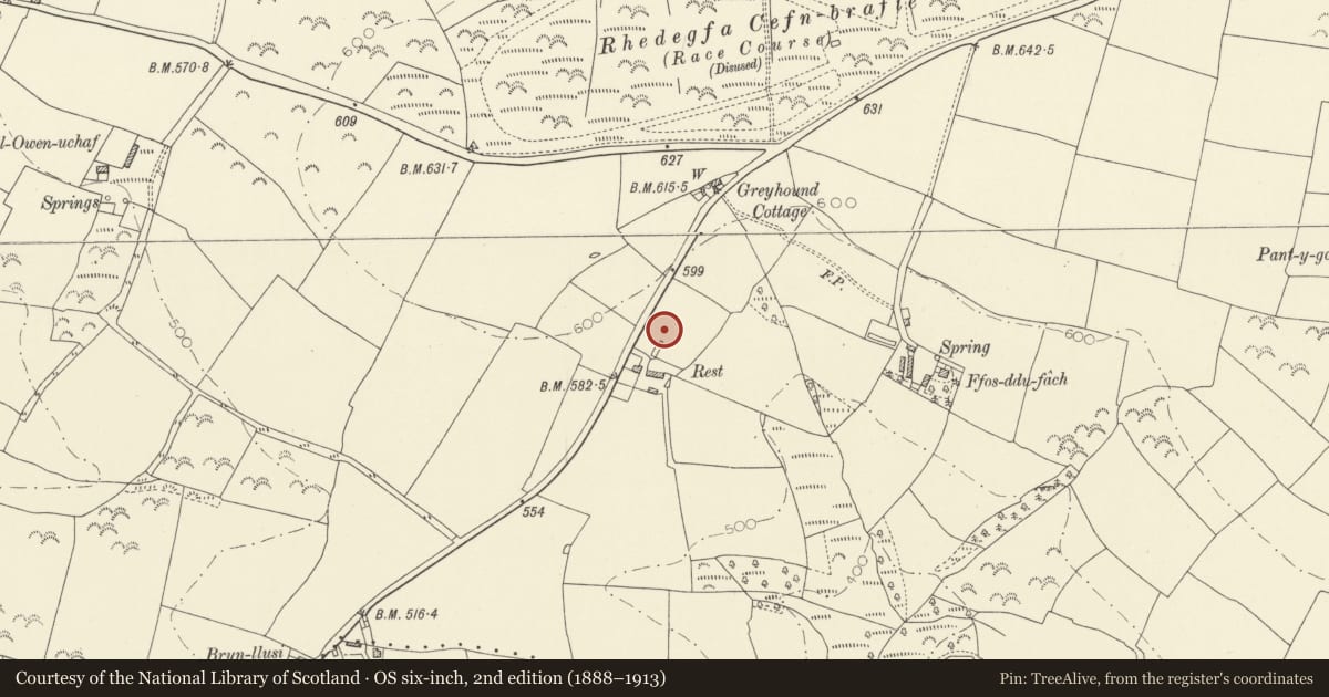
Slide toward Today to fade the historical sheet and see the modern map underneath.
David Rumsey Map Collection, Stanford LibrariesDavid Rumsey Map Collection, Stanford LibrariesDavid Rumsey Map Collection, Stanford LibrariesDavid Rumsey Map Collection, Stanford LibrariesDavid Rumsey Map Collection, Stanford Libraries
5 historical maps cover this location, the earliest the 1636 map "Cornubia : Devonia, Somersetus, Dorcestria, Wiltonia, Glocestria ..." (David Rumsey Map Collection, Stanford Libraries).
Historical maps covering this location
- 1636 · Cornubia : Devonia, Somersetus, Dorcestria, Wiltonia, Glocestria ... (David Rumsey Map Collection, Stanford Libraries)
- 1830 · V.3:11-15:XV. Britisches Reich. A. Kon: England. b. Frstenthum Wales: Shire: 37-40 (David Rumsey Map Collection, Stanford Libraries)
- 1891 · Sheet 10. Ordnance Survey of England and Wales. . (David Rumsey Map Collection, Stanford Libraries)
- 1898 · 210 Cardigan (Hills) (David Rumsey Map Collection, Stanford Libraries)
- 1901 · Sheet 13. (David Rumsey Map Collection, Stanford Libraries)
Cadw's description
Location
Situated on E side of road about 1 km ESE of Crosshands crossroads.
History
Farmhouse mid C19 built for the Maesgwynne estate and apparently named in connection with the racecourse established nearby by W.R.H. Powell in the mid C19, for which the Maesgwynne Arms Hotel in Llanboidy was also built. The horses were rested here after racing. Not marked on 1839 Llangan Tithe map.
Exterior
Farmhouse, painted stucco with slate roof and rendered end wall stacks. L-plan Two-storey, three-window S front with stucco quoins and hoodmoulds to 12-pane sashes and centre door in later C19 brick and timber porch with coloured glass margins to glazed panels of double doors. Bracketted eaves and small half-hip to roof on W gable also with brackets. Rear has NW outshut and NE wing. Small 12-pane sash in outshut W end wall which is whitewashed stone.
Interior
Not inspected.
Reason for designation
Included as a mid C19 farmhouse of character associated with the Maesgwynne estate racecourse.
Nearby in the register
- Burial Chamber near Cross HandsChambered Tombunder 1 mi
- CilgynyddDomesticunder 1 mi
- Outbuilding behind CilgynyddAgriculture and Subsistenceunder 1 mi
- Lofted cartshed at CilgynyddAgriculture and Subsistenceunder 1 mi
Other entries of the same register within about three miles of this one, by straight line.