Cof Cymru: National Historic Assets of Wales · Wales
Barn at Village Farm
Raglan, Monmouthshire, Wales
A Grade II listed building in Llandenny, Raglan, Monmouthshire, designated on 31 January 2001.
The record
- Designation
- Listed building, Grade II
- Broad class
- Agriculture and Subsistence
- Date of designation
- 31 January 2001
- Locality
- Llandenny
- Town
- Raglan
- Community
- Raglan
- Unitary authority
- Monmouthshire
- Country
- Wales
- Coordinates
- 51.73050, -2.84820
- Cadw reference
- 24746
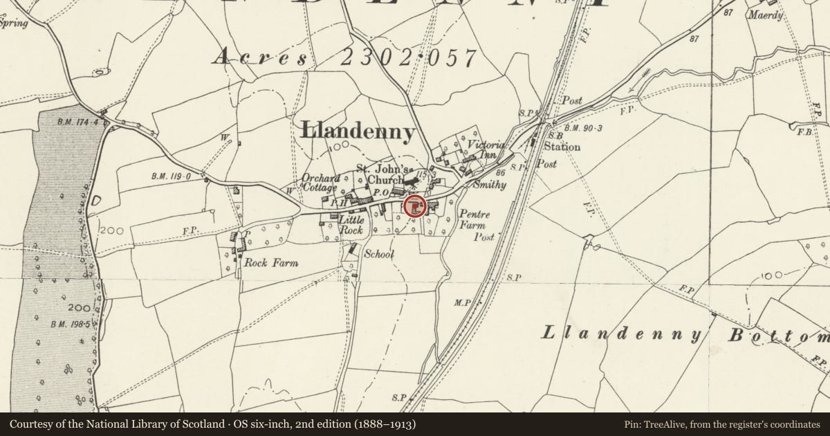
Slide toward Today to fade the historical sheet and see the modern map underneath.
David Rumsey Map Collection, Stanford LibrariesDavid Rumsey Map Collection, Stanford LibrariesDavid Rumsey Map Collection, Stanford LibrariesDavid Rumsey Map Collection, Stanford LibrariesDavid Rumsey Map Collection, Stanford Libraries
5 historical maps cover this location, the earliest the 1636 map "Cornubia : Devonia, Somersetus, Dorcestria, Wiltonia, Glocestria ..." (David Rumsey Map Collection, Stanford Libraries).
Historical maps covering this location
- 1636 · Cornubia : Devonia, Somersetus, Dorcestria, Wiltonia, Glocestria ... (David Rumsey Map Collection, Stanford Libraries)
- 1830 · V.3:11-15:XV.Britisches Reich. A. Kon: England. a. England ab sich: Shire:15-17, 33 (David Rumsey Map Collection, Stanford Libraries)
- 1895 · Sheet 11. Ordnance Survey of England and Wales. (David Rumsey Map Collection, Stanford Libraries)
- 1896 · 233 Monmouth (Hills) (David Rumsey Map Collection, Stanford Libraries)
- 1913 · Sheet 102. Newport. (David Rumsey Map Collection, Stanford Libraries)
Cadw's description
Location
Situated in Llandenny village opposite entry to churchyard, at upper W side of farmyard at the former Pentre Farm, now Village Farm.
History
Barn, possibly C18, part of the farmyard group at The Pentre. The farm name was lost c1999 when the house, now Church Farm, was divided from the outbuildings, now Village Farm, the outbuildings intended for residential development..
Exterior
Barn, whitewashed rubble stone with asbestos roof. E front off-centre full-height double doors with one vent loop left and 2 loops right. Ground floor left board door. N end wall has large loft opening in gable with timber lintel. Rear W side concrete tiles, barn door with head under catslide roof. Three loops.
Interior
Four-bay roof with tie-beam and angle-strut trusses, raised floor in left bay on rubble stone wall.
Reason for designation
Included as a C18 stone barn of group value with Church Farmhouse and its outbuilding, now Village Farm. The whole group is of value in the village setting.
Nearby in the register
- Village FarmAgriculture and Subsistenceunder 1 mi
- Lych-gate to the church of St JohnReligious, Ritual and Funeraryunder 1 mi
- Church FarmDomesticunder 1 mi
- Cross in St John's churchyardReligious, Ritual and Funeraryunder 1 mi
Other entries of the same register within about three miles of this one, by straight line.