Cof Cymru: National Historic Assets of Wales · Wales
Nurse Cottage
Ysceifiog, Flintshire, Wales
A Grade II listed building in Afonwen, Mold, Ysceifiog, Flintshire, designated on 31 January 2001.
The record
- Designation
- Listed building, Grade II
- Broad class
- Domestic
- Date of designation
- 31 January 2001
- Locality
- Afonwen
- Town
- Mold
- Community
- Ysceifiog
- Unitary authority
- Flintshire
- Country
- Wales
- Coordinates
- 53.24583, -3.28730
- Cadw reference
- 24678
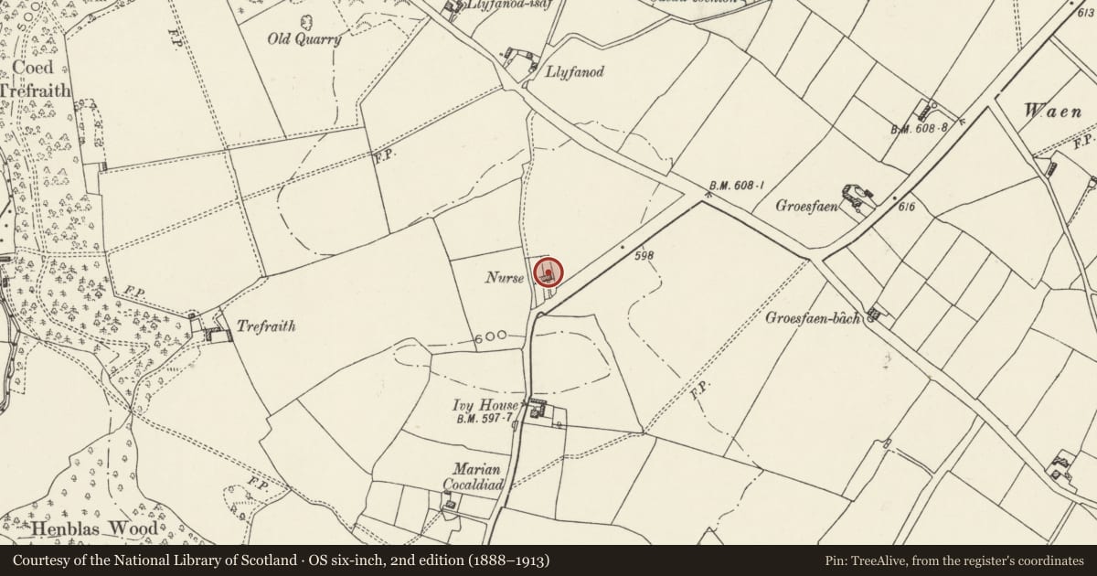
Slide toward Today to fade the historical sheet and see the modern map underneath.
David Rumsey Map Collection, Stanford LibrariesDavid Rumsey Map Collection, Stanford LibrariesDavid Rumsey Map Collection, Stanford LibrariesDavid Rumsey Map Collection, Stanford LibrariesLlyfrgell Genedlaethol Cymru – The National Library of Wales
5 historical maps cover this location, the earliest the 1795 map "To Sir Watkin Williams-Wynn Bart ... the map of the six counties of North Wales is most humbly inscribed by his obedient humble servant" (Llyfrgell Genedlaethol Cymru – The National Library of Wales).
Historical maps covering this location
- 1795 · To Sir Watkin Williams-Wynn Bart ... the map of the six counties of North Wales is most… (Llyfrgell Genedlaethol Cymru – The National Library of Wales)
- 1883 · Watershed map England, Wales 3. (David Rumsey Map Collection, Stanford Libraries)
- 1898 · 108 Flint (Hills) (David Rumsey Map Collection, Stanford Libraries)
- 1898 · 108 Flint (Outline) (David Rumsey Map Collection, Stanford Libraries)
- 1901 · Sheet 9 and 10. (David Rumsey Map Collection, Stanford Libraries)
Cadw's description
Location
Approximately 1.8km NW of Ysceifiog and set back on the N side of aminor road between Afonwen and Babell.
History
Built as a pair of single-unit squatter cottages on Brynford Common and described as an 'encroachment' on the 1849 Tithe apportionment. The cottages became a single dwelling in the second half of the C20 when addition were made at the rear to replace early lean-tos.
Exterior
A reflected pair of 2-storey single-window cottages of whitened rubble stone and replaced concrete tile roof, and end stone stacks. The doorways are set on the inner sides of the cottages. On the L side this has a replaced boarded door, on the R side now infilled and replaced by a top-hung casement window. Similar top-hung casements are on the outer sides in the lower storey, and have been inserted in original openings to replace horizontal sashes in the upper storey. The R-hand cottage has a single-storey projection to the R-hand side with a boarded door. The rear has lower flat-roofed projections to each cottage.
Interior
The single-unit interiors are retained, each cottage having a simple fireplace stair with wooden treads and balusters. Either side of the fireplace are cupboards with wooden doors.
Reason for designation
Listed as a rare example of C19 squatter cottages retaining early character.
Nearby in the register
- Round Barrow 450m SSW of LlynfanodRound Barrowunder 1 mi
- Round Barrow WSW of LlyfanodRound Barrowunder 1 mi
- Llyfanod round barrowRound Barrowunder 1 mi
- Round Barrow 180m NW of GroesfaenRound Barrowunder 1 mi
Other entries of the same register within about three miles of this one, by straight line.