Cof Cymru: National Historic Assets of Wales · Wales
Brewery/Laundry range at Peniarth
Llanegryn, Gwynedd, Wales
A Grade II listed building in Llanegryn, Gwynedd, designated on 26 July 2000.
The record
- Designation
- Listed building, Grade II
- Broad class
- Domestic
- Date of designation
- 26 July 2000
- Locality
- Llanegryn
- Community
- Llanegryn
- Unitary authority
- Gwynedd
- Country
- Wales
- Coordinates
- 52.62857, -4.05248
- Cadw reference
- 23777
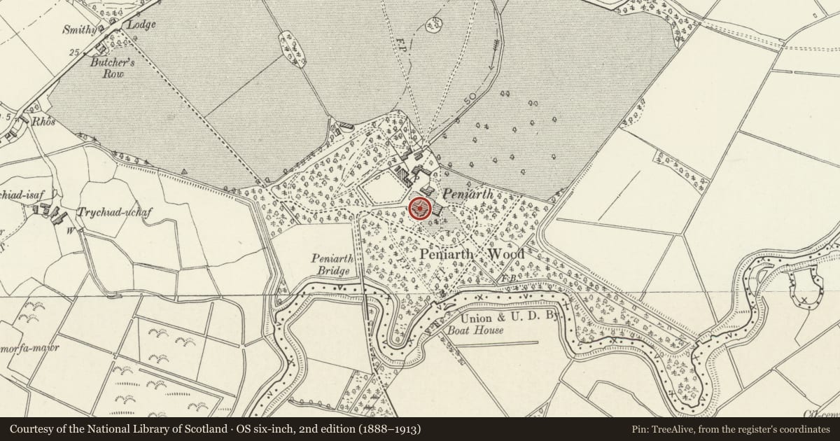
Slide toward Today to fade the historical sheet and see the modern map underneath.
David Rumsey Map Collection, Stanford LibrariesDavid Rumsey Map Collection, Stanford LibrariesDavid Rumsey Map Collection, Stanford LibrariesDavid Rumsey Map Collection, Stanford LibrariesLlyfrgell Genedlaethol Cymru – The National Library of Wales
5 historical maps cover this location, the earliest the 1795 map "To Sir Watkin Williams-Wynn Bart ... the map of the six counties of North Wales is most humbly inscribed by his obedient humble servant" (Llyfrgell Genedlaethol Cymru – The National Library of Wales).
Historical maps covering this location
- 1795 · To Sir Watkin Williams-Wynn Bart ... the map of the six counties of North Wales is most… (Llyfrgell Genedlaethol Cymru – The National Library of Wales)
- 1883 · Watershed map England, Wales 3. (David Rumsey Map Collection, Stanford Libraries)
- 1896 · Sheet 7. Ordnance Survey of England and Wales. (David Rumsey Map Collection, Stanford Libraries)
- 1899 · 149 Barmouth (Hills) (David Rumsey Map Collection, Stanford Libraries)
- 1901 · Sheet 9 and 10. (David Rumsey Map Collection, Stanford Libraries)
Cadw's description
Location
The building stands almost directly behind the service range at the back of the main house, aligned SE-NW.
History
This outbuilding, which is of C18 origin, provided for various services for the great house, including a brewhouse at the SE end, later used as a laundry, and a gig house at the NW end.
Exterior
Built of brick and stone, with a slate roof. Single storey with an added C19 slated open-fronted verandah along the NE side on slender iron columns, forming approximately 7 bays. The end gables have raised quoins, rising to kneelers and a moulded coped gable to the NW. The brewhouse at the SE end, has a C18 facade of brick with stone quoins, providing an acceptable face towards the house. Plat band and parapet with stone moulded copings. Two windows to the upper level with flat rubbed brick lintels. This elevation has been recently rebuilt, incorporating new joinery in the existing openings. Wynne arms applied to the parapet. Under the verandah, five timber battened doors to service rooms, interspersed with various windows. Cobbles and setts paving. At the NW end, a blocked carriage arch with rubbed brick voussoirs.
Reason for designation
Included as an outbuilding of some architectural quality with good detail, part of the setting of the Grade II* main house with which it has group value.
Nearby in the register
- PeniarthDomesticunder 1 mi
- The Clock HouseCommercialunder 1 mi
- Service yard range of buildings at PeniarthDomesticunder 1 mi
- Gate piers at the W driveway to PeniarthDomesticunder 1 mi
Other entries of the same register within about three miles of this one, by straight line.