Cof Cymru: National Historic Assets of Wales · Wales
3 Heol Tan-y-bryn
Llanfihangel-y-Pennant, Gwynedd, Wales
A Grade II listed building in Abergynolwyn, Tywyn, Llanfihangel-y-Pennant, Gwynedd, designated on 10 April 2000.
The record
- Designation
- Listed building, Grade II
- Broad class
- Domestic
- Date of designation
- 10 April 2000
- Locality
- Abergynolwyn
- Town
- Tywyn
- Community
- Llanfihangel-y-Pennant
- Unitary authority
- Gwynedd
- Country
- Wales
- Coordinates
- 52.64393, -3.95517
- Cadw reference
- 23170
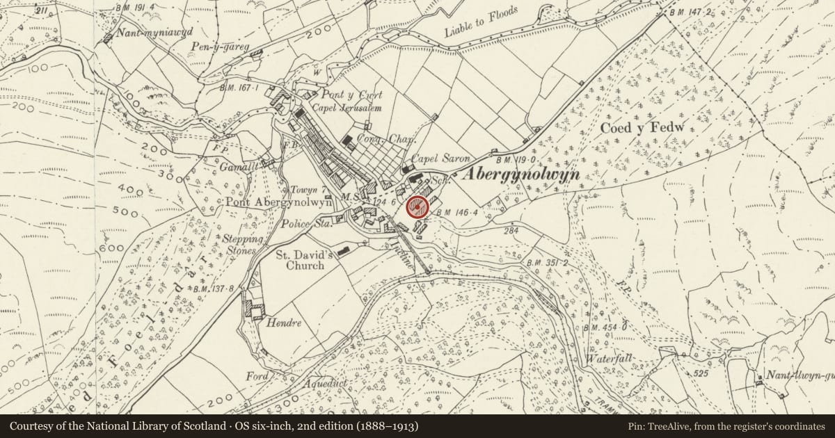
Slide toward Today to fade the historical sheet and see the modern map underneath.
David Rumsey Map Collection, Stanford LibrariesDavid Rumsey Map Collection, Stanford LibrariesDavid Rumsey Map Collection, Stanford LibrariesLlyfrgell Genedlaethol Cymru – The National Library of WalesDavid Rumsey Map Collection, Stanford Libraries
5 historical maps cover this location, the earliest the 1795 map "To Sir Watkin Williams-Wynn Bart ... the map of the six counties of North Wales is most humbly inscribed by his obedient humble servant" (Llyfrgell Genedlaethol Cymru – The National Library of Wales).
Historical maps covering this location
- 1795 · To Sir Watkin Williams-Wynn Bart ... the map of the six counties of North Wales is most… (Llyfrgell Genedlaethol Cymru – The National Library of Wales)
- 1883 · Watershed map England, Wales 3. (David Rumsey Map Collection, Stanford Libraries)
- 1896 · Sheet 7. Ordnance Survey of England and Wales. (David Rumsey Map Collection, Stanford Libraries)
- 1899 · 149 Barmouth (Hills) (David Rumsey Map Collection, Stanford Libraries)
- 1901 · Sheet 9 and 10. (David Rumsey Map Collection, Stanford Libraries)
Cadw's description
Location
Heol Tan-y-bryn is a development of two confronting terraces of houses running NE-SW, on the S side of Abergynolwyn.
History
The houses fronting Tan-y-bryn were designed by T H Connell for the Aberdovey Slate Co Ltd between 1865 and 1868. It consited of a street of two facing rows of 22 houses also by T H Connell, the 12 on the N side containing a parlour, living room, kitchen and 3 bedrooms. On the S side 5 larger houses had four bedrooms, presumably the houses at the W end of the S side, and 6 were smaller with only two bedrooms. One other was to a different plan, presumably incorporated a shop. All had back gardens. The quarry was sold in 1879, and closed in 1909, but was re-formed as the Abergynolwyn Slate and Slab Co Ltd in 1911, continuing production into the late 1920s.
Exterior
Upper panels of the door are glazed. Original windows.
Reason for designation
Included as part of a mid-later C19 formally planned development of high quality workers' dwellings of urban character for a specific local industry. Retains much of its original character and detail.
Nearby in the register
- 4 Heol Tan-y-brynDomesticunder 1 mi
- 2 Heol Tan-y-brynDomesticunder 1 mi
- 5 Heol Tan-y-brynDomesticunder 1 mi
- DolawelDomesticunder 1 mi
Other entries of the same register within about three miles of this one, by straight line.