Cof Cymru: National Historic Assets of Wales · Wales
12 Dulais Fach Road
Tonna, Neath Port Talbot, Wales
A Grade II listed building in Aberdulais, Tonna, Neath Port Talbot, designated on 25 February 2000.
The record
- Designation
- Listed building, Grade II
- Broad class
- Domestic
- Date of designation
- 25 February 2000
- Locality
- Aberdulais
- Community
- Tonna
- Unitary authority
- Neath Port Talbot
- Country
- Wales
- Coordinates
- 51.67892, -3.77125
- Cadw reference
- 22871
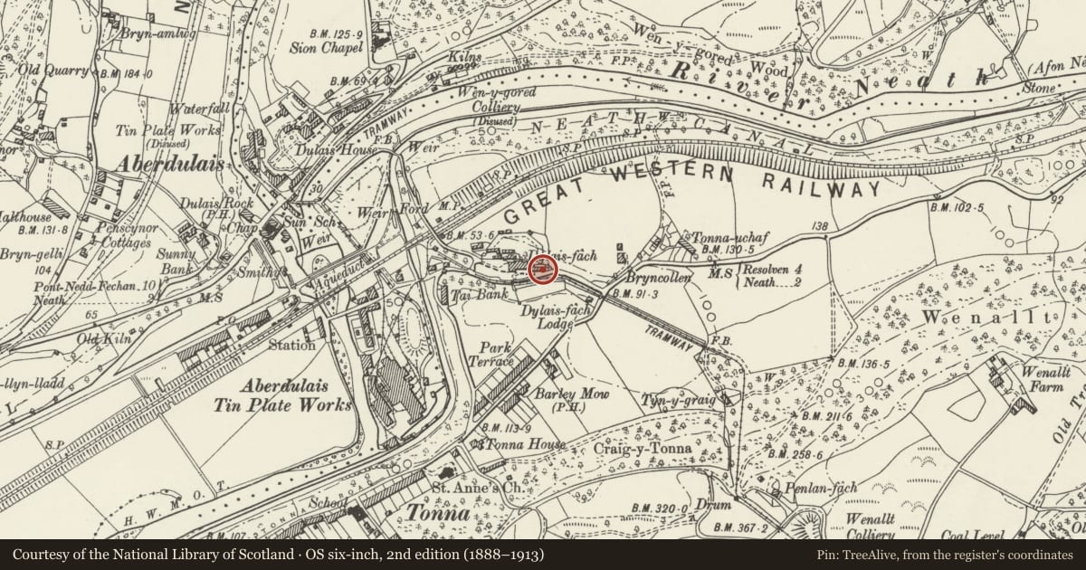
Slide toward Today to fade the historical sheet and see the modern map underneath.
David Rumsey Map Collection, Stanford LibrariesDavid Rumsey Map Collection, Stanford LibrariesDavid Rumsey Map Collection, Stanford LibrariesDavid Rumsey Map Collection, Stanford LibrariesDavid Rumsey Map Collection, Stanford Libraries
5 historical maps cover this location, the earliest the 1636 map "Cornubia : Devonia, Somersetus, Dorcestria, Wiltonia, Glocestria ..." (David Rumsey Map Collection, Stanford Libraries).
Historical maps covering this location
- 1636 · Cornubia : Devonia, Somersetus, Dorcestria, Wiltonia, Glocestria ... (David Rumsey Map Collection, Stanford Libraries)
- 1637 · The fourth table of England. Cornub. Devonia, Somerset etc. (David Rumsey Map Collection, Stanford Libraries)
- 1865 · England and Wales. England No. 6. (David Rumsey Map Collection, Stanford Libraries)
- 1891 · Sheet 10. Ordnance Survey of England and Wales. . (David Rumsey Map Collection, Stanford Libraries)
- 1897 · 247 Swansea (Hills) (David Rumsey Map Collection, Stanford Libraries)
Cadw's description
Location
On the E side of Dulais Fach.
History
Built as a coach house and possibly a lodge for Dulais Fach in the 3rd quarter of the C19 and first shown on the 1877 Ordnance Survey. It was probably built when the main house was extended by the addition of a new entrance block. The building has now been converted to a single dwelling, but originally consisted of 3 units, namely the coach house at the S end and 2 heated units to the centre and N side next to Dulais Fach that may have contained workshops, office or domestic accommodation.
Exterior
A one-and-a-half-storey former coach house of snecked sandstone with dressed quoins, segmental-headed openings with brick dressings and small-pane glazing. A hipped roof has projecting eaves, stone stacks on the L side and R of centre, and is renewed with synthetic slates. To the R of the central panelled door is a 2-light casement and further R a ventilation strip. To the L of the doorway is a fixed-pane window and a 2-light casement and doorway at the L end with a replaced glazed door. To the R and L of the doorways are gabled roof dormers with 2-light casements. Attached to the L end is a lower gabled extension in snecked stone (in the ownership of Dulais Fach). A later brick wall is attached to the R end. In the R end wall is a wide segmental-headed former carriage entrance with French doors inserted.
Interior
Not inspected.
Reason for designation
Listed for group value with Dulais Fach and Dulais Isaf House.
Nearby in the register
- Dulais FachDomesticunder 1 mi
- Dulais Isaf HouseDomesticunder 1 mi
- Railway bridge on NE side of Railway TavernTransportunder 1 mi
- Aberdulais Basin at the head of the Tennant CanalTransportunder 1 mi
Other entries of the same register within about three miles of this one, by straight line.