Cof Cymru: National Historic Assets of Wales · Wales
Capel-y-Wern
Llanrhaeadr-Yng-Nghinmeirch, Denbighshire, Wales
A Grade II listed building in Llanrhaeadr, Denbigh, Llanrhaeadr-Yng-Nghinmeirch, Denbighshire, designated on 29 November 1999.
The record
- Designation
- Listed building, Grade II
- Broad class
- Religious, Ritual and Funerary
- Date of designation
- 29 November 1999
- Locality
- Llanrhaeadr
- Town
- Denbigh
- Community
- Llanrhaeadr-Yng-Nghinmeirch
- Unitary authority
- Denbighshire
- Country
- Wales
- Coordinates
- 53.14014, -3.38137
- Cadw reference
- 22692
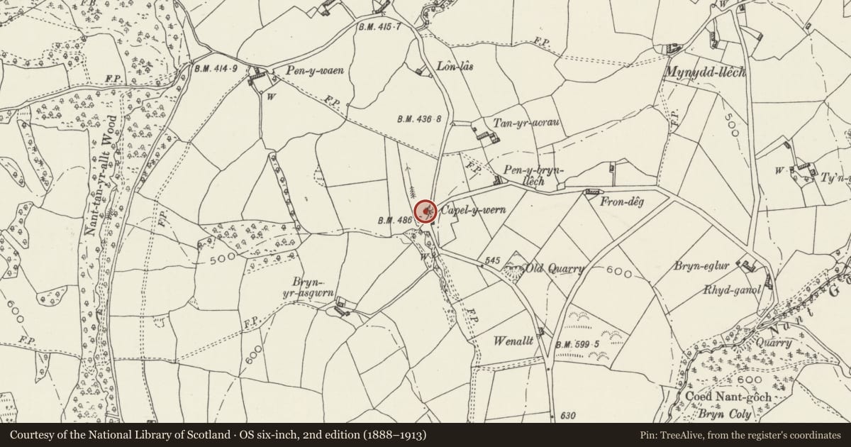
Slide toward Today to fade the historical sheet and see the modern map underneath.
David Rumsey Map Collection, Stanford LibrariesLlyfrgell Genedlaethol Cymru – The National Library of WalesDavid Rumsey Map Collection, Stanford LibrariesDavid Rumsey Map Collection, Stanford LibrariesDavid Rumsey Map Collection, Stanford Libraries
5 historical maps cover this location, the earliest the 1608 map "(13) Cambriae Typus." (David Rumsey Map Collection, Stanford Libraries).
Historical maps covering this location
- 1608 · (13) Cambriae Typus. (David Rumsey Map Collection, Stanford Libraries)
- 1795 · To Sir Watkin Williams-Wynn Bart ... the map of the six counties of North Wales is most… (Llyfrgell Genedlaethol Cymru – The National Library of Wales)
- 1830 · V.3:11-15:XV. Britisches Reich. A. Kon: England. b. Frstenthum Wales: Shire: 37-40 (David Rumsey Map Collection, Stanford Libraries)
- 1883 · Watershed map England, Wales 3. (David Rumsey Map Collection, Stanford Libraries)
- 1901 · Sheet 9 and 10. (David Rumsey Map Collection, Stanford Libraries)
Cadw's description
Location
Prominently sited at a cross-roads towards the eastern boundary of the community, some 1.6km SW of Llanrhaeadr on a lane leading to Cyffylliog; set behind a low rubble wall enclosing a shallow forecourt, with plain iron gate.
History
Second-quarter C19 chapel with early C20 porch addition.
Exterior
Small rectangular chapel. Of roughcast rubble construction with rusticated quoins of raised plaster and moulded plaster architraves to the windows. C20 slate roof with deep verges, modern bargeboards and wooden finials to the gable ends. The main (road-facing) side has an off-centre entrance to the R with 2 flanking windows to the L and one to the R. Early C20 gabled porch of roughcast brick, with slate roof and plain bargeboards; open front with small 2-part windows to the sides and slate name plaque above the entrance. Original 2-part boarded door within, with ironwork handle and pegged wooden frame; wide, simply-moulded architrave. Original 12-pane unhorned sash windows, recessed, with moulded plaster architraves and projecting stone sills. Below that to the R is a boarded 2-light cellar window. The R gable has a boarded door and a slated lean-to Ty Bach, also with boarded door. Three similar windows to the rear.
Interior
Original simple, grained pine box pews in raking arrangement from the R to the Set Fawr at L. Full-height vertically-boarded sides and plain plaster ceiling. Simple canted, panelled Set Fawr, with moulded cornice and 2-panel rear with painted Welsh text band above.
Reason for designation
Listed for its special interest as a second-quarter C19 chapel in a rural road-side location, retaining good original character.
Nearby in the register
- Agricultural Range at Carreg-y-PennillAgriculture and Subsistenceunder 1 mi
- Carreg-y-PennillDomesticunder 1 mi
- Cartshed to the N of Carreg-y-PennillAgriculture and Subsistenceunder 1 mi
- Agricultural Range at Cae SerwydAgriculture and Subsistenceunder 1 mi
Other entries of the same register within about three miles of this one, by straight line.