Cof Cymru: National Historic Assets of Wales · Wales
Nos.3 & 4 Ffrwd
Llandwrog, Gwynedd, Wales
A Grade II listed building in Llandwrog, Caernarfon, Gwynedd, designated on 30 September 1999.
The record
- Designation
- Listed building, Grade II
- Broad class
- Domestic
- Date of designation
- 30 September 1999
- Locality
- Llandwrog
- Town
- Caernarfon
- Community
- Llandwrog
- Unitary authority
- Gwynedd
- Country
- Wales
- Coordinates
- 53.08025, -4.30624
- Cadw reference
- 22425
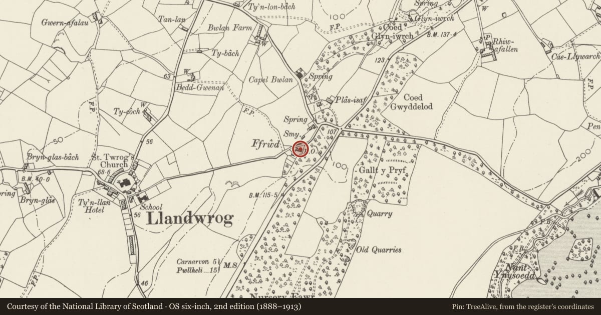
Slide toward Today to fade the historical sheet and see the modern map underneath.
David Rumsey Map Collection, Stanford LibrariesDavid Rumsey Map Collection, Stanford LibrariesNational Library of ScotlandDavid Rumsey Map Collection, Stanford LibrariesLlyfrgell Genedlaethol Cymru – The National Library of Wales
5 historical maps cover this location, the earliest the 1795 map "To Sir Watkin Williams-Wynn Bart ... the map of the six counties of North Wales is most humbly inscribed by his obedient humble servant" (Llyfrgell Genedlaethol Cymru – The National Library of Wales).
Historical maps covering this location
- 1795 · To Sir Watkin Williams-Wynn Bart ... the map of the six counties of North Wales is most… (Llyfrgell Genedlaethol Cymru – The National Library of Wales)
- 1883 · Watershed map England, Wales 3. (David Rumsey Map Collection, Stanford Libraries)
- 1888 · Caernarvonshire Sheet XVI.SW (National Library of Scotland)
- 1896 · Sheet 7. Ordnance Survey of England and Wales. (David Rumsey Map Collection, Stanford Libraries)
- 1901 · Sheet 9 and 10. (David Rumsey Map Collection, Stanford Libraries)
Cadw's description
Location
Situated on bend of very narrow road approximately 0.5km east of Llandwrog; low rubblestone wall enclosing front gardens has been partly demolished to provide widened access, in the case of No. 4 for vehicles; stone dividing wall between cottages.
History
Built as a pair of Glynllifon Estate workers' cottages between c1860 and c1870 as the third Lord Newborough turned his attention from the rebuilding of the village, largely complete by 1860, towards the building and remodelling of farms and cottages elsewhere on the estate.
Exterior
Long single-storey central range with equal-height 2-storey gabled ranges projecting to front, very similar in basic plan-form to the roughly contemporary Ysgol Llandwrog in the nearby village. Irregularly coursed rubblestone with slate-stone lintels and cills; renewed slate roof. Front in 1:2:1 bays, windows all wooden multi-paned mullioned and transomed windows in 3 lights (lower section vertically sliding) on ground floor and smaller 3-light mullioned and transomed windows to gables; entrances through shallow gabled porches to inner returns. 2 rendered ridge stacks to main range, one to ridge of left gable and another stack to right of right gable. Left gable (part of No.4) has rooflight in each roof slope.
Interior
Interior not inspected at time of Survey.
Reason for designation
Included as a well-preserved pair of substantially built workers' houses provided by the third Lord Newborough as part of the reordering of the Wynn family estate in the mid C19. The cottages retain the symmetrical composition and joinery detail characteristic of the Estate's work in this area at this time, while Llandwrog itself is among the best-preserved estate villages in this part of Wales from this period.
Nearby in the register
- Cottage/outbuilding at Tan-y-groeslonDomesticunder 1 mi
- Tan-y-groeslonDomesticunder 1 mi
- North LodgeDomesticunder 1 mi
- Cemetery Walls and GatesReligious, Ritual and Funeraryunder 1 mi
Other entries of the same register within about three miles of this one, by straight line.