Cof Cymru: National Historic Assets of Wales · Wales
SE range of farm buildings at Hafod-y-wern
Clynnog, Gwynedd, Wales
A Grade II listed building in Clynnog-fawr, Caernarfon, Clynnog, Gwynedd, designated on 15 September 1999.
The record
- Designation
- Listed building, Grade II
- Broad class
- Agriculture and Subsistence
- Date of designation
- 15 September 1999
- Locality
- Clynnog-fawr
- Town
- Caernarfon
- Community
- Clynnog
- Unitary authority
- Gwynedd
- Country
- Wales
- Coordinates
- 53.01610, -4.35720
- Cadw reference
- 22354
Slide toward Today to fade the historical sheet and see the modern map underneath.
David Rumsey Map Collection, Stanford LibrariesDavid Rumsey Map Collection, Stanford LibrariesDavid Rumsey Map Collection, Stanford LibrariesDavid Rumsey Map Collection, Stanford LibrariesLlyfrgell Genedlaethol Cymru – The National Library of Wales
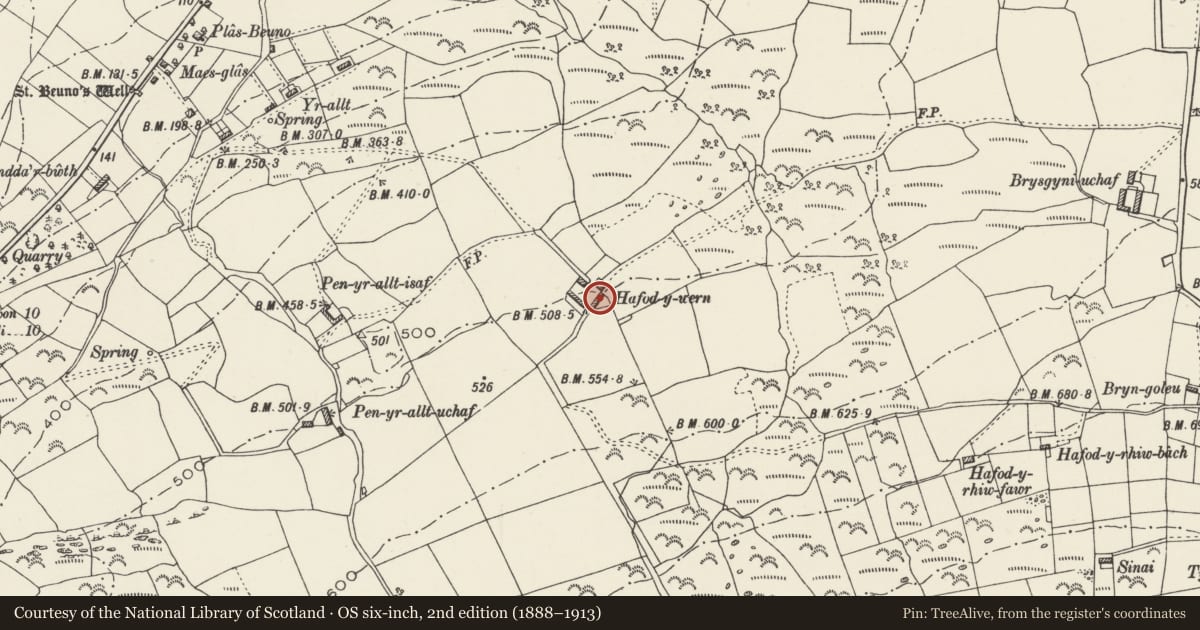
5 historical maps cover this location, the earliest the 1795 map "To Sir Watkin Williams-Wynn Bart ... the map of the six counties of North Wales is most humbly inscribed by his obedient humble servant" (Llyfrgell Genedlaethol Cymru – The National Library of Wales).
Historical maps covering this location
- 1795 · To Sir Watkin Williams-Wynn Bart ... the map of the six counties of North Wales is most… (Llyfrgell Genedlaethol Cymru – The National Library of Wales)
- 1883 · Watershed map England, Wales 3. (David Rumsey Map Collection, Stanford Libraries)
- 1896 · Sheet 7. Ordnance Survey of England and Wales. (David Rumsey Map Collection, Stanford Libraries)
- 1899 · 118 Nevin (Hills) (David Rumsey Map Collection, Stanford Libraries)
- 1901 · Sheet 9 and 10. (David Rumsey Map Collection, Stanford Libraries)
Cadw's description
Location
Hafod-y-wern stands on a hilltop above Clynnog-fawr, reached by farm track and small road at the side of the Post Office.
History
The square farmyard lies immediately SW of the house. It was built in the mid-later C19 by the Glynllifon Estate, with a range of stables and barn on the SE, a range of cowhouses on the SW, and a piggery at the N corner. A stone lined driftway extends from the S corner.
Exterior
The SE range is built of stone, with slate roofs. Nearest the farm, a workshop, followed by a 2-bay stable, perhaps originally a barn, with two ventilation slits and a granary over furnished with bins, approached by a dog-leg stair, a 2-bay stable for working heavy horses, and, at the far end, 3 loose boxes for calves etc. A water wheel formerly stood in the narrow stone trough at the near end of the range, the outfall running across the farmyard in a stone covered culvert. Along the front a raised pavement for dryshod access. Timber stable doors, and ventilated windows, but one later wide opening.
Reason for designation
Included as an integral part of the mid C19 planned estate farmstead associated with the extended farmhouse at Hafod-y-wern.
Nearby in the register
- Hafod-y-wern FarmhouseDomesticunder 1 mi
- SW range of farm buildings at Hafod-y-wernAgriculture and Subsistenceunder 1 mi
- Piggery at Hafod-y-wernAgriculture and Subsistenceunder 1 mi
- Pen yr allt IsafDomesticunder 1 mi
Other entries of the same register within about three miles of this one, by straight line.