Cof Cymru: National Historic Assets of Wales · Wales
Former Post Office & Nos 1-3 Maes Gerddi
Llanrug, Gwynedd, Wales
A Grade II listed building in Tan-y-coed, Llanrug, Gwynedd, designated on 7 May 1999.
The record
- Designation
- Listed building, Grade II
- Broad class
- Commercial
- Date of designation
- 7 May 1999
- Locality
- Tan-y-coed
- Community
- Llanrug
- Unitary authority
- Gwynedd
- Country
- Wales
- Coordinates
- 53.13977, -4.18835
- Cadw reference
- 21640
Slide toward Today to fade the historical sheet and see the modern map underneath.
David Rumsey Map Collection, Stanford LibrariesDavid Rumsey Map Collection, Stanford LibrariesDavid Rumsey Map Collection, Stanford LibrariesDavid Rumsey Map Collection, Stanford LibrariesDavid Rumsey Map Collection, Stanford Libraries
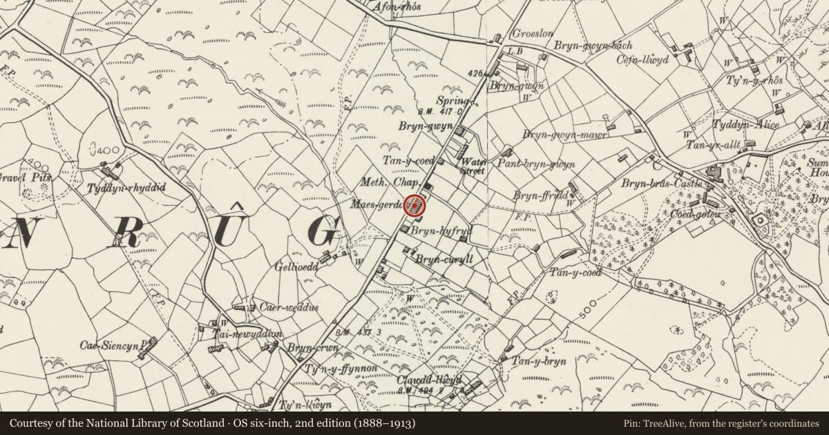
5 historical maps cover this location, the earliest the 1896 map "Sheet 7. Ordnance Survey of England and Wales." (David Rumsey Map Collection, Stanford Libraries).
Historical maps covering this location
- 1896 · Sheet 7. Ordnance Survey of England and Wales. (David Rumsey Map Collection, Stanford Libraries)
- 1899 · 106 Bangor (Outline) (David Rumsey Map Collection, Stanford Libraries)
- 1899 · 106 Bangor (Hills) (David Rumsey Map Collection, Stanford Libraries)
- 1901 · Sheet 9 and 10. (David Rumsey Map Collection, Stanford Libraries)
- 1919 · Sheet 41. Anglesey. (David Rumsey Map Collection, Stanford Libraries)
Cadw's description
Location
Located on the east side of the road between Llanrug and Ceunant immediately to the south-west of the chapel and Sunday School at Tan-y-coed; the cottages behind a low stone wall with railings, the post office slightly set back from the road.
History
Late C19 purpose-built development of Post Office/shop and attached terraced cottages forming part of the small late C19 roadside settlement at Tan-y-coed. The Post Office/shop is now closed.
Exterior
Post office/shop and attached terraced cottages. Long 2-storey row of buildings consisting of post office/shop at north-eastern end and 3 attached cottages; continuous roofline to post office/shop and No 1, stepped up to Nos 2 & 3. Roughly coursed rubblestone, with late C20 repointing to No 3; slate roof. Post office/shop has 16-paned sash window directly below eaves to left with fixed-light window immediately below, boarded doors on both floors to centre and late C19 shop-front to right with integral boarded door (on left) and console brackets, above which are two 4-paned sashes; truncated end stack to left, brick ridge stack to centre and rendered ridge stack to right at junction with No. 1. This has 3-window front with 4-paned sashes throughout and central half-glazed door; brick stack to right at junction with No 2. Both this and No 3 are of 2 bays with C20 half-glazed doors to left and shared ridge stack; C20 top-hung windows throughout, those to No 2 replacing the original plate-glass sashes in January or February 1999. Rear has continuous catslide lean-tos to post office/shop and No 1, flanking shallow-pitched lean-to below first-floor windows. C19 rooflight to post office/shop.
Interior
Interior not inspected at time of Survey.
Reason for designation
Included as a well-preserved example of a small late C19 roadside development of shop and attached terraced cottages retaining its original form and much of its original detailing.
Nearby in the register
- Sunday School/Vestry at Capel Tan-y-coedReligious, Ritual and Funeraryunder 1 mi
- Capel Tan-y-coedReligious, Ritual and Funeraryunder 1 mi
- Bryn Bras CastleDomesticunder 1 mi
- Gladiator statue (north) at Bryn Bras CastleGardens, Parks and Urban Spacesunder 1 mi
Other entries of the same register within about three miles of this one, by straight line.