Cof Cymru: National Historic Assets of Wales · Wales
Field Cowhouse [beudy] at Glasfryn-bach
Llannor, Gwynedd, Wales
A Grade II listed building in Llwyndyrys, Pwllheli, Llannor, Gwynedd, designated on 8 February 1999.
The record
- Designation
- Listed building, Grade II
- Broad class
- Agriculture and Subsistence
- Date of designation
- 8 February 1999
- Locality
- Llwyndyrys
- Town
- Pwllheli
- Community
- Llannor
- Unitary authority
- Gwynedd
- Country
- Wales
- Coordinates
- 52.95559, -4.39703
- Cadw reference
- 21333
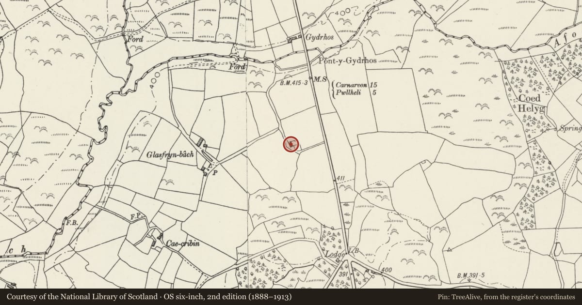
Slide toward Today to fade the historical sheet and see the modern map underneath.
David Rumsey Map Collection, Stanford LibrariesDavid Rumsey Map Collection, Stanford LibrariesDavid Rumsey Map Collection, Stanford LibrariesDavid Rumsey Map Collection, Stanford LibrariesLlyfrgell Genedlaethol Cymru – The National Library of Wales
5 historical maps cover this location, the earliest the 1795 map "To Sir Watkin Williams-Wynn Bart ... the map of the six counties of North Wales is most humbly inscribed by his obedient humble servant" (Llyfrgell Genedlaethol Cymru – The National Library of Wales).
Historical maps covering this location
- 1795 · To Sir Watkin Williams-Wynn Bart ... the map of the six counties of North Wales is most… (Llyfrgell Genedlaethol Cymru – The National Library of Wales)
- 1883 · Watershed map England, Wales 3. (David Rumsey Map Collection, Stanford Libraries)
- 1896 · Sheet 7. Ordnance Survey of England and Wales. (David Rumsey Map Collection, Stanford Libraries)
- 1899 · 118 Nevin (Hills) (David Rumsey Map Collection, Stanford Libraries)
- 1901 · Sheet 9 and 10. (David Rumsey Map Collection, Stanford Libraries)
Cadw's description
Location
The building lies on the right side of the driveway to Glasfryn-bach farm, approximately 100m from the main Caernarfon road.
History
The building was probably erected in the early C19 for farm use.
Exterior
The building is built of local boulders, with a grouted slate roof and imposed coping slates. Five bays, with a 3-bay cowhouse at the E end, and a single boarded door on the S side, and 2-bays stable at the N end, with access from the rear. Some corbelled stones built in to the N side.
Interior
A stone wall divides the two parts. The cowhouse has a feed walk against the dividing wall, accessed from the S side, with a door into the beudy. The stable has a manger across the W gable wall. Collar beam trusses, the principals set into the walls, and carrying two tiers of purlins. Scratched marks on one collar.
Reason for designation
Included as a good example of a simple farm building retaining its original openings, roof structure and covering, characteristic of the Lleyn peninsula.
Nearby in the register
- Walls flanking the W approach to the courtyard of Glasfryn, including Glasfryn-uchafDomesticunder 1 mi
- Hut Group North-East of Carnguwch FawrHut groupunder 1 mi
- Glasfryn Coach HouseDomesticunder 1 mi
- Glasfryn HouseDomesticunder 1 mi
Other entries of the same register within about three miles of this one, by straight line.