Cof Cymru: National Historic Assets of Wales · Wales
Lychgate at the Parish Church of St Michael and All Angels
Efenechtyd, Denbighshire, Wales
A Grade II listed building in Efenechtyd, Denbighshire, designated on 25 January 1999.
The record
- Designation
- Listed building, Grade II
- Broad class
- Religious, Ritual and Funerary
- Date of designation
- 25 January 1999
- Locality
- Efenechtyd
- Community
- Efenechtyd
- Unitary authority
- Denbighshire
- Country
- Wales
- Coordinates
- 53.09166, -3.32842
- Cadw reference
- 21217
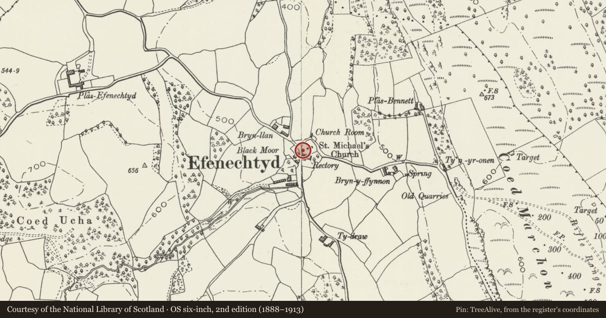
Slide toward Today to fade the historical sheet and see the modern map underneath.
David Rumsey Map Collection, Stanford LibrariesDavid Rumsey Map Collection, Stanford LibrariesLlyfrgell Genedlaethol Cymru – The National Library of WalesDavid Rumsey Map Collection, Stanford LibrariesDavid Rumsey Map Collection, Stanford Libraries
5 historical maps cover this location, the earliest the 1795 map "To Sir Watkin Williams-Wynn Bart ... the map of the six counties of North Wales is most humbly inscribed by his obedient humble servant" (Llyfrgell Genedlaethol Cymru – The National Library of Wales).
Historical maps covering this location
- 1795 · To Sir Watkin Williams-Wynn Bart ... the map of the six counties of North Wales is most… (Llyfrgell Genedlaethol Cymru – The National Library of Wales)
- 1830 · V.3:11-15:XV. Britisches Reich. A. Kon: England. b. Frstenthum Wales: Shire: 37-40 (David Rumsey Map Collection, Stanford Libraries)
- 1883 · Watershed map England, Wales 3. (David Rumsey Map Collection, Stanford Libraries)
- 1898 · 121 Wrexham (Hills) (David Rumsey Map Collection, Stanford Libraries)
- 1901 · Sheet 9 and 10. (David Rumsey Map Collection, Stanford Libraries)
Cadw's description
Location
Prominently-located on a bend in the main street in the village centre, at the SW end of the rubble-walled churchyard and adjoining the Rectory at its SE corner.
History
Lychgate, probably of C18 date, built to serve the parish church. A series of incorporated sandstone corbels represent reuse of earlier material, possibly medieval.
Exterior
Limestone rubble construction with pitched slate roof and sandstone ridges; oversailing eaves and deep verges with expressed purlin ends. The roof is carried on rounded sandstone corbels, two to each face of the supporting gable walls. Late C19 panelled oak half-gates to the front (facing SW), with simple pierced tracery to the upper section. Towards the NE end are contemporary narrow rubble benches to the inner walls.
Reason for designation
Listed for its special interest as a lychgate of probable C18 date, in a prominent location within the village.
Group value with the Parish Church of St Michael and All Angels.
Nearby in the register
- Parish Church of St Michael and All AngelsReligious, Ritual and Funeraryunder 1 mi
- Plas-yn-LlanDomesticunder 1 mi
- Gatepiers and associated Forecourt Walls at Plas-yn-LlanDomesticunder 1 mi
- Primary House at Plas-yn-LlanAgriculture and Subsistenceunder 1 mi
Other entries of the same register within about three miles of this one, by straight line.