Cof Cymru: National Historic Assets of Wales · Wales
Ty-draw Farmhouse
Llancarfan, Vale of Glamorgan, Wales
A Grade II listed building in Llantrithyd, Llancarfan, Vale of Glamorgan, designated on 15 January 1998.
The record
- Designation
- Listed building, Grade II
- Broad class
- Domestic
- Date of designation
- 15 January 1998
- Locality
- Llantrithyd
- Community
- Llancarfan
- Unitary authority
- Vale of Glamorgan
- Country
- Wales
- Coordinates
- 51.44532, -3.39118
- Cadw reference
- 19227
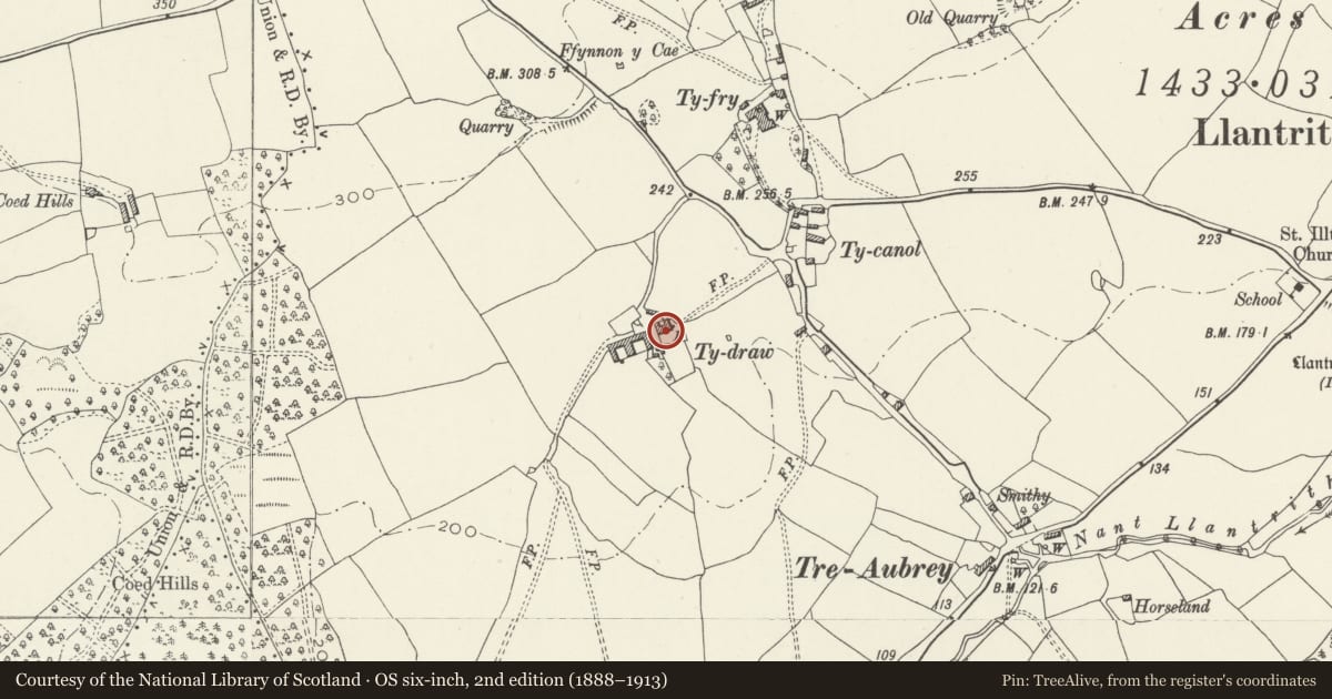
Slide toward Today to fade the historical sheet and see the modern map underneath.
David Rumsey Map Collection, Stanford LibrariesDavid Rumsey Map Collection, Stanford LibrariesDavid Rumsey Map Collection, Stanford LibrariesDavid Rumsey Map Collection, Stanford LibrariesDavid Rumsey Map Collection, Stanford Libraries
5 historical maps cover this location, the earliest the 1636 map "Cornubia : Devonia, Somersetus, Dorcestria, Wiltonia, Glocestria ..." (David Rumsey Map Collection, Stanford Libraries).
Historical maps covering this location
- 1636 · Cornubia : Devonia, Somersetus, Dorcestria, Wiltonia, Glocestria ... (David Rumsey Map Collection, Stanford Libraries)
- 1637 · The fourth table of England. Cornub. Devonia, Somerset etc. (David Rumsey Map Collection, Stanford Libraries)
- 1865 · England and Wales. England No. 6. (David Rumsey Map Collection, Stanford Libraries)
- 1897 · 262 Pontypridd (Hills) (David Rumsey Map Collection, Stanford Libraries)
- 1897 · 262 Pontypridd (Outline) (David Rumsey Map Collection, Stanford Libraries)
Cadw's description
Location
About 1.2km west of Llantrithyd Church to S of minor road between Llantrithyd and St Hilary. Entrance faces south.
History
Probable origins as C17 house, rebuilt in C18, and modernised in C19 with new roof, insertion of sash windows. The fine C16/C17 panelling in the parlour was probably taken from the nearby ruinous Llantrithyd Place.
Exterior
Two storey, 4-window farmhouse; roughcast render over local rubble; slate roof with 3 dressed stone chimneys. Asymmetrical front with roughly central main doorway. First floor has four 12-pane hornless sash windows. On ground floor, roughly central doorway (boarded door) to R of which are two 16-pane horned sash windows; to L of doorway, 16-pane sash window, and additional doorway under modern glazed porch. To R, single-storey block with sash window and pitched slate roof. Left gable is slate-hung with first floor window. To rear, crosswings at E and W ends of building; W crosswing of 2 storeys, 2 windows, loading door to first floor of N gable; shallow 2-storey block in angle with main block. East crosswing is single storey.
Interior
Interior largely modernised in C19. Parlour has, against rear wall, high quality wooden panelling, reputedly from Llantrithyd Place, consisting of fielded wainscotting with ornate frieze. The panelling is partially fitted on its side, and frieze consists of pieces which do not fit together well; cupboard to R panelled as wall.
Reason for designation
Listed as part of good farm group, and for panelling from Llantrithyd Place. Group value with adjacent agricultural range.
Nearby in the register
- Agricultural Range at Ty-draw FarmAgriculture and Subsistenceunder 1 mi
- Circular Pigsty at the MeadowsAgriculture and Subsistenceunder 1 mi
- Llantrithyd CampEnclosureunder 1 mi
- Horseland moated homesteadMoated Siteunder 1 mi
Other entries of the same register within about three miles of this one, by straight line.