Cof Cymru: National Historic Assets of Wales · Wales
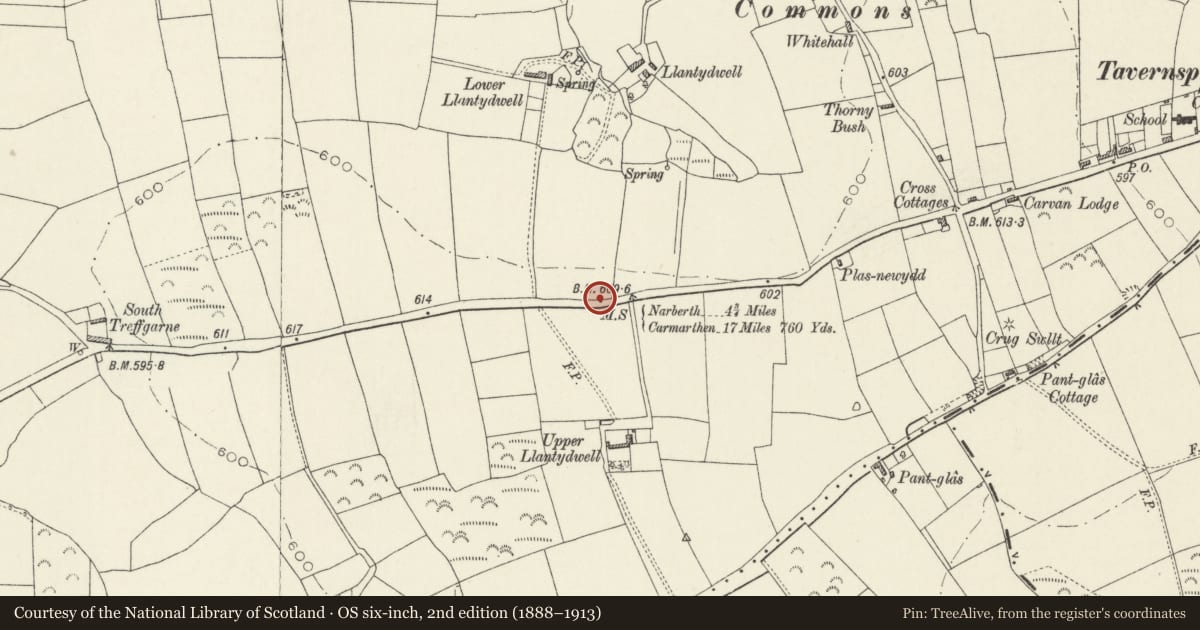
Milepost near Lower Llantydwell
Lampeter Velfrey, Pembrokeshire, Wales
A Grade II listed building in Llantydwell, Lampeter Velfrey, Pembrokeshire, designated on 15 October 1997.
The record
- Designation
- Listed building, Grade II
- Broad class
- Transport
- Date of designation
- 15 October 1997
- Locality
- Llantydwell
- Community
- Lampeter Velfrey
- Unitary authority
- Pembrokeshire
- Country
- Wales
- Coordinates
- 51.78004, -4.65273
- Cadw reference
- 18988
Slide toward Today to fade the historical sheet and see the modern map underneath.
David Rumsey Map Collection, Stanford LibrariesDavid Rumsey Map Collection, Stanford LibrariesDavid Rumsey Map Collection, Stanford LibrariesDavid Rumsey Map Collection, Stanford LibrariesDavid Rumsey Map Collection, Stanford Libraries
5 historical maps cover this location, the earliest the 1636 map "Cornubia : Devonia, Somersetus, Dorcestria, Wiltonia, Glocestria ..." (David Rumsey Map Collection, Stanford Libraries).
Historical maps covering this location
- 1636 · Cornubia : Devonia, Somersetus, Dorcestria, Wiltonia, Glocestria ... (David Rumsey Map Collection, Stanford Libraries)
- 1830 · V.3:11-15:XV. Britisches Reich. A. Kon: England. b. Frstenthum Wales: Shire: 37-40 (David Rumsey Map Collection, Stanford Libraries)
- 1891 · Sheet 10. Ordnance Survey of England and Wales. . (David Rumsey Map Collection, Stanford Libraries)
- 1898 · 228 Haverfordwest (Hills) (David Rumsey Map Collection, Stanford Libraries)
- 1901 · Sheet 13. (David Rumsey Map Collection, Stanford Libraries)
Cadw's description
Location
100 m E of the lane to Lower Llantydwell Farm.
History
A milepost on one of the roads which were shown on the map in the 1844 Inquiry Report as managed by the Tavernspite Turnpike Trust. The Trust appears to be of C18 origin. It was controlled under an act of 1808. Following the Rebecca riots all Pembrokeshire turnpike roads were taken over in 1845 by the County Roads Board. It was probably after this consolidation that the foundry of Joseph Marychurch, Haverfordwest, cast the plates for the mileposts.
Exterior
Milepost consisting of two cast-iron plates each with its top pointed. The plates are butted together at 90 degrees, fixed to a solid backing but not fixed to each other.
The W-facing plate reads '17 miles 760 yards to Carmarthen'. The E-facing plate reads '4 miles to Narberth'. Both plates have the wording 'Marychurch Foundry' in smaller lettering at the foot. This milepost is the second on the Tavernspite turnpike.
Reason for designation
Listed as a C19 cast-iron milepost of distinctive local type.
Nearby in the register
- Crug Swllt Round BarrowRound Barrowunder 1 mi
- Cyffic and Lampeter Velfrey Parish Boundary StoneCivilunder 1 mi
- Milepost in Tavernspite villageTransportunder 1 mi
- Milepost at Glan RhydTransportunder 1 mi
Other entries of the same register within about three miles of this one, by straight line.