Cof Cymru: National Historic Assets of Wales · Wales
Glantorfaen House
Pontymoile, Torfaen, Wales
A Grade II listed building in Pontypool, Pontymoile, Torfaen, designated on 28 August 1997.
The record
- Designation
- Listed building, Grade II
- Broad class
- Commercial
- Date of designation
- 28 August 1997
- Locality
- Pontypool
- Town
- Pontypool
- Community
- Pontymoile
- Unitary authority
- Torfaen
- Country
- Wales
- Coordinates
- 51.70185, -3.04024
- Cadw reference
- 18812
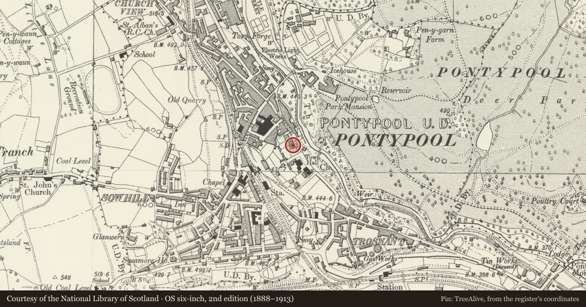
Slide toward Today to fade the historical sheet and see the modern map underneath.
David Rumsey Map Collection, Stanford LibrariesDavid Rumsey Map Collection, Stanford LibrariesDavid Rumsey Map Collection, Stanford LibrariesDavid Rumsey Map Collection, Stanford LibrariesDavid Rumsey Map Collection, Stanford Libraries
5 historical maps cover this location, the earliest the 1636 map "Cornubia : Devonia, Somersetus, Dorcestria, Wiltonia, Glocestria ..." (David Rumsey Map Collection, Stanford Libraries).
Historical maps covering this location
- 1636 · Cornubia : Devonia, Somersetus, Dorcestria, Wiltonia, Glocestria ... (David Rumsey Map Collection, Stanford Libraries)
- 1830 · V.3:11-15:XV.Britisches Reich. A. Kon: England. a. England ab sich: Shire:15-17, 33 (David Rumsey Map Collection, Stanford Libraries)
- 1895 · Sheet 11. Ordnance Survey of England and Wales. (David Rumsey Map Collection, Stanford Libraries)
- 1906 · 249 Newport (Hills) (David Rumsey Map Collection, Stanford Libraries)
- 1913 · Sheet 102. Newport. (David Rumsey Map Collection, Stanford Libraries)
Cadw's description
Location
In Pontypool town centre at the junction of Commercial Street and Glentorvaen Road.
History
A Victorian office block or business premises built in 1860-1870 with characteristic Ruskinian Gothic details on the porch which date it to post the publication of 'The Stones of Venice' in 1851-3. Of some historic interest as the long time headquarters of Pontypool Urban District Council (1894-1974), and possibly of the Pontypool Local Board before that.
Exterior
A large square three storey and basement block of squared grey rock faced coursed limestone with ashlar dressings and squared pink limestone rubble on the return elevation. The front elevation is five windows wide, segmental heads with keystones on the ground floor, segmental plain heads on the first floor and smaller, with square heads on the top floor. All windows have dressed surrounds,and are modern replacement ones with one over one panes, the lower of which hinges outwards. Central recessed doorway with panelled door, dressed surround with segmental head, and fanlight over. The central first floor window is an oriel with Venetian window and sidelights. The Venetian window has a keyed head and roundels on either side. Tented lead roof to oriel. Plat band at first floor level. Eaves cornice, roof not visible from street.
Side elevation to Glentorvaen Road has an extravagantly detailed projecting porch placed centrally. This has square piers with horizontal rustication, stiff-leaf caps and rising into panelled blocks above; and an arched entrance supported by paired Ruskinian Gothic stiff-leaf colonnettes in polished red granite. The arch has panelled squinches with roundels, cornice on paired brackets above. The sides are treated similarly with arch headed windows. The door is flanked by one over one sash windows. The plat band is returned above the porch forming a cill band for a single tall stair window in three panes, one above another, segmental head. Cornice, central dormer window above with segmental roof.
Interior
Interior not inspected at time of resurvey (October 1996).
Reason for designation
Included for the special interest of the porch and for group value with neighbouring listed buildings in Commercial Street and Hanbury Road.
Nearby in the register
- Lloyd's BankCommercialunder 1 mi
- Pearl Assurance HouseCommercialunder 1 mi
- 35 Commercial StreetCommercialunder 1 mi
- Pontypool Public LibraryEducationunder 1 mi
Other entries of the same register within about three miles of this one, by straight line.