Cof Cymru: National Historic Assets of Wales · Wales
Former Corn Mill
Ysbyty Ifan, Conwy, Wales
A Grade II listed building in Ysbyty Ifan, Conwy, designated on 8 April 1997.
The record
- Designation
- Listed building, Grade II
- Broad class
- Industrial
- Date of designation
- 8 April 1997
- Locality
- Ysbyty Ifan
- Community
- Ysbyty Ifan
- Unitary authority
- Conwy
- Country
- Wales
- Coordinates
- 53.02400, -3.72826
- Cadw reference
- 18308
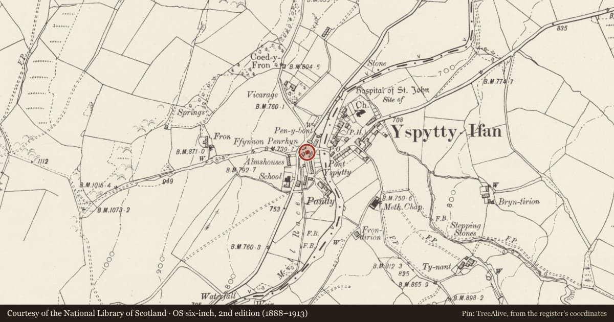
Slide toward Today to fade the historical sheet and see the modern map underneath.
David Rumsey Map Collection, Stanford LibrariesDavid Rumsey Map Collection, Stanford LibrariesLlyfrgell Genedlaethol Cymru – The National Library of WalesDavid Rumsey Map Collection, Stanford LibrariesDavid Rumsey Map Collection, Stanford Libraries
5 historical maps cover this location, the earliest the 1795 map "To Sir Watkin Williams-Wynn Bart ... the map of the six counties of North Wales is most humbly inscribed by his obedient humble servant" (Llyfrgell Genedlaethol Cymru – The National Library of Wales).
Historical maps covering this location
- 1795 · To Sir Watkin Williams-Wynn Bart ... the map of the six counties of North Wales is most… (Llyfrgell Genedlaethol Cymru – The National Library of Wales)
- 1830 · V.3:11-15:XV. Britisches Reich. A. Kon: England. b. Frstenthum Wales: Shire: 37-40 (David Rumsey Map Collection, Stanford Libraries)
- 1883 · Watershed map England, Wales 3. (David Rumsey Map Collection, Stanford Libraries)
- 1898 · 120 Corwen (Hills) (David Rumsey Map Collection, Stanford Libraries)
- 1901 · Sheet 9 and 10. (David Rumsey Map Collection, Stanford Libraries)
Cadw's description
Location
Set back slightly at the village crossroads diagonally opposite Pont Ysbyty Ifan.
History
Second-quarter or mid-C19 century water-powered corn mill. A corn mill is recorded at Ysbyty Ifan in documents of 1746 and 1767, and is described as stone-built and slated in the latter. It is possible that the present, C19 mill was a rebuilding of this earlier mill which, in fragment, may be incorporated. The wheel and machinery are apparently replacements of the late C19; the mill was worked until c1960.
Exterior
2-storey water-driven corn mill of coursed, rough-dressed rubble under a medium-pitched old slate roof. Symmetrical 3-bay entrance front (NW-facing) with central entrance and original recessed, boarded stable door; simple decorative iron hinges, pegged wooden surround. Flanking this, two square 2-light boarded windows and, to the first floor, three equally-spaced square windows with C20 6-pane fixed glazing. The ground-floor openings have large dressed slate lintels, recessed slightly below narrow returned labels. The SW side has a large wheel pit with external pitchback, iron-rimmed waterwheel of approximately 4m diameter; wooden struts and paddles survive, no visible foundry plate. To the L of this a 2-light shuttered window and to the upper floor, three windows as before. Gable entrances to both ends, that to the SW raised and with external stepped access; boarded door, modern metal handrail. The NE gable entrance is accessed via two worn steps and has its original boarded stable door and pegged frame; lintel as before. Small square vent-light to gable apex.
Interior
The internal machinery is mostly intact, although to a large degree replaced in the late C19: iron toothed wheel and 4 pairs of stones; overhead shafting and wheels to first floor, together with sack hoist and wooden stairs; plain pine joists to ceiling.
Reason for designation
Listed for its special historic interest as a fine C19 village corn mill retaining its machinery.
Group value with other listed items at Ysbyty Ifan.
Nearby in the register
- 1 Mill StreetDomesticunder 1 mi
- 2 Mill StreetDomesticunder 1 mi
- 3 Mill StreetDomesticunder 1 mi
- Former Wheelwright's Workshop.Industrialunder 1 mi
Other entries of the same register within about three miles of this one, by straight line.