Cof Cymru: National Historic Assets of Wales · Wales
Explosives store of former Llantrisant Colliery
Llanharan, Rhondda Cynon Taff, Wales
A Grade II listed building in Ynysmaerdy, Llanharan, Rhondda Cynon Taff, designated on 7 October 1994.
The record
- Designation
- Listed building, Grade II
- Broad class
- Industrial
- Date of designation
- 7 October 1994
- Locality
- Ynysmaerdy
- Community
- Llanharan
- Unitary authority
- Rhondda Cynon Taff
- Country
- Wales
- Coordinates
- 51.54887, -3.39817
- Cadw reference
- 15843
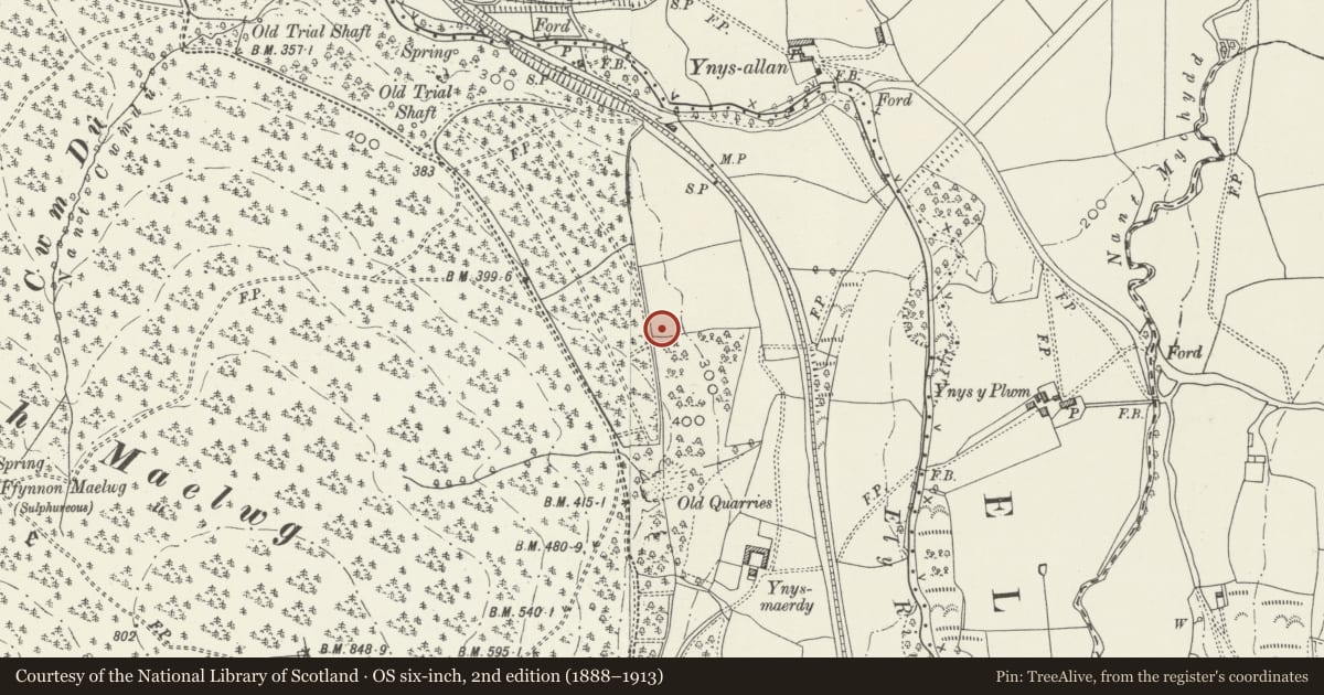
Slide toward Today to fade the historical sheet and see the modern map underneath.
David Rumsey Map Collection, Stanford LibrariesDavid Rumsey Map Collection, Stanford LibrariesDavid Rumsey Map Collection, Stanford LibrariesDavid Rumsey Map Collection, Stanford LibrariesDavid Rumsey Map Collection, Stanford Libraries
5 historical maps cover this location, the earliest the 1636 map "Cornubia : Devonia, Somersetus, Dorcestria, Wiltonia, Glocestria ..." (David Rumsey Map Collection, Stanford Libraries).
Historical maps covering this location
- 1636 · Cornubia : Devonia, Somersetus, Dorcestria, Wiltonia, Glocestria ... (David Rumsey Map Collection, Stanford Libraries)
- 1637 · The fourth table of England. Cornub. Devonia, Somerset etc. (David Rumsey Map Collection, Stanford Libraries)
- 1865 · England and Wales. England No. 6. (David Rumsey Map Collection, Stanford Libraries)
- 1895 · Sheet 11. Ordnance Survey of England and Wales. (David Rumsey Map Collection, Stanford Libraries)
- 1907 · 248 Pontypridd (Hills) (David Rumsey Map Collection, Stanford Libraries)
Cadw's description
Location
Located in the SW corner of a field NW of the colliery complex.
History
Llantrisant or Ynysmaerdy Colliery was established by the Powell Duffryn Steam Coal Company after World War I. It closed in 1942 following an underground explosion. It was constructed on the efficient modern model developed by the Powell Duffryn Company, with a single engine hall containing the main power equipment needed on the surface. The site is a particularly complete and impressive colliery complex, containing the engine hall, workshops and stores, ruined offices, a separate winding engine house, railway lines, tips, a long revetment wall, a reservoir, and an explosives store. It was associated with the planned housing estate at Ynysmaerdy.
Exterior
The explosives store was situated away from the colliery buildings to minimise the damage caused by any explosions. It is typical of magazines of this date in being of brick with no internal materials likely to create sparks, a vaulted roof and thick walls; but it is unusual in having a reinforced concrete roof instead of the more common brick vault. It is a small brick and concrete single-storey building on a level platform cut into the steep hillside. The walls have a pronounced batter. The whole structure is rendered to the outside to protect from damp and frost. There is a tall window at a high level at each end, and small square ventilation holes all around. The steel door is at the E end hanging on iron hinges on the outside of the building and has screw holes for fixing timber panelling to the inside to avoid sparks. It is rare that such doors remain in place.
Reason for designation
Listed as well preserved example of a colliery explosives store and for group value in this unusually complete and impressive colliery complex.
Nearby in the register
- Cow Shed at Ynysmaerdy Farm (formerly stores of Llantrisant Colliery)Agriculture and Subsistenceunder 1 mi
- Reservoir of former Llantrisant CollieryIndustrialunder 1 mi
- Engine Hall of former Llantrisant CollieryIndustrialunder 1 mi
- Revetment wall of former Llantrisant CollieryIndustrialunder 1 mi
Other entries of the same register within about three miles of this one, by straight line.