Cof Cymru: National Historic Assets of Wales · Wales
Belan Place
Ruabon, Wrexham, Wales
A Grade II listed building in Rhosmadoc, Ruabon, Wrexham, designated on 22 February 1995.
The record
- Designation
- Listed building, Grade II
- Broad class
- Domestic
- Date of designation
- 22 February 1995
- Locality
- Rhosmadoc
- Community
- Ruabon
- Unitary authority
- Wrexham
- Country
- Wales
- Coordinates
- 52.97083, -3.02864
- Cadw reference
- 15732
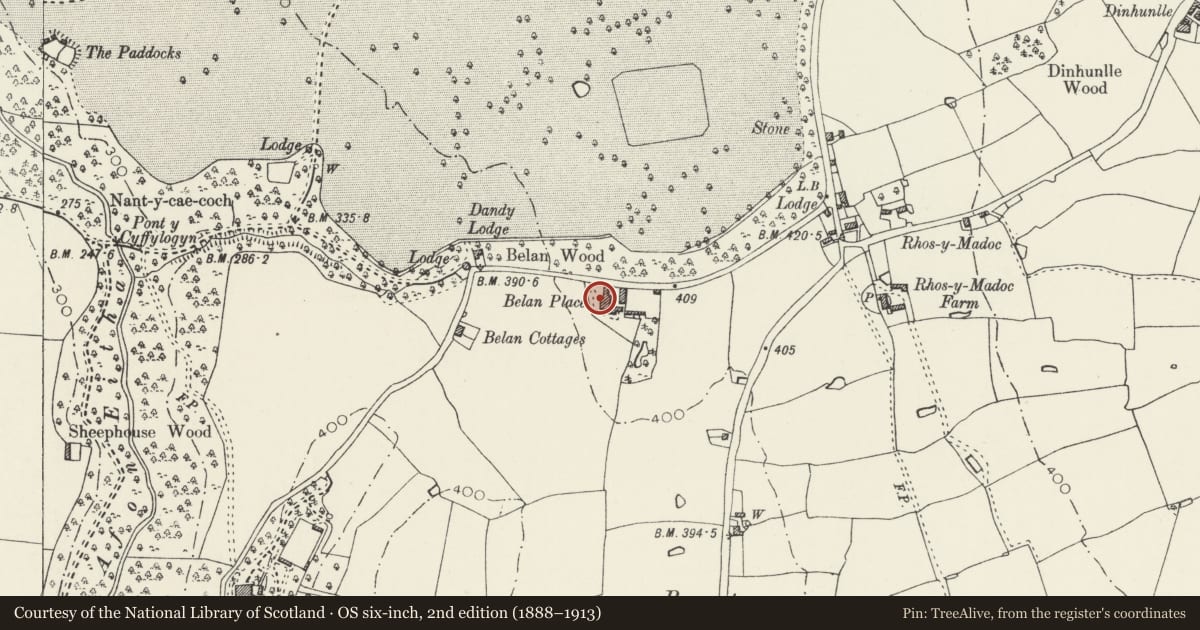
Slide toward Today to fade the historical sheet and see the modern map underneath.
David Rumsey Map Collection, Stanford LibrariesDavid Rumsey Map Collection, Stanford LibrariesDavid Rumsey Map Collection, Stanford LibrariesDavid Rumsey Map Collection, Stanford LibrariesLlyfrgell Genedlaethol Cymru – The National Library of Wales
5 historical maps cover this location, the earliest the 1795 map "To Sir Watkin Williams-Wynn Bart ... the map of the six counties of North Wales is most humbly inscribed by his obedient humble servant" (Llyfrgell Genedlaethol Cymru – The National Library of Wales).
Historical maps covering this location
- 1795 · To Sir Watkin Williams-Wynn Bart ... the map of the six counties of North Wales is most… (Llyfrgell Genedlaethol Cymru – The National Library of Wales)
- 1883 · Watershed map England, Wales 3. (David Rumsey Map Collection, Stanford Libraries)
- 1898 · 121 Wrexham (Hills) (David Rumsey Map Collection, Stanford Libraries)
- 1898 · 121 Wrexham (Outline) (David Rumsey Map Collection, Stanford Libraries)
- 1901 · Sheet 9 and 10. (David Rumsey Map Collection, Stanford Libraries)
Cadw's description
Location
Situated 350m W of Rhosymadoc reached from a private road running SW of Rhosymadoc.
History
Formerly the Dower House for Wynnstay Hall, probably built by the Williams-Wynn family in the mid/late C18. Now a private house.
Exterior
3 storey, red brick main elevation faces west: flemish bond with rusticated stone quoins. 3-bays wide with pedimented central bay projecting slightly forward. Slate roof and brick stacks. Single storey brick extensions at ground floor contain later canted bay windows and curved entrance porch. Porch has two arch headed windows in the curve of the wall, central glazed door with margin light, stone shouldered architrave. Flanking bays have tripartite small-pane sash glazing. Right hand return elevation later 2-storey extension with slate roof, renewed windows and door.
Interior
Present kitchen retains large central recessed sandstone arch, flanked by two smaller arches marking probable former range position. Number of high quality mahogany 6-panel doors. Barrel vaulted red brick cellars containing original doors and slate shelves.
Reason for designation
Listed as a good example of a mid/late C18 house which retains much of its character and has historical associations with the Wynnstay Estate.
Group value with the Stables and Coach House and Terrier Kennels at Belan Place.
Nearby in the register
- Coach House at Belan PlaceDomesticunder 1 mi
- Terrier Kennels at Belan PlaceDomesticunder 1 mi
- StablesDomesticunder 1 mi
- House attached to School RoomDomesticunder 1 mi
Other entries of the same register within about three miles of this one, by straight line.