Cof Cymru: National Historic Assets of Wales · Wales
White Cottage
Llandrillo-yn-Rhos / Rhos-on-Sea, Conwy, Wales
A Grade II listed building in Rhos on Sea, Llandrillo-yn-Rhos / Rhos-on-Sea, Conwy, designated on 9 September 1994.
The record
- Designation
- Listed building, Grade II
- Broad class
- Domestic
- Date of designation
- 9 September 1994
- Locality
- Rhos on Sea
- Community
- Llandrillo-yn-Rhos / Rhos-on-Sea
- Unitary authority
- Conwy
- Country
- Wales
- Coordinates
- 53.31259, -3.74171
- Cadw reference
- 14840
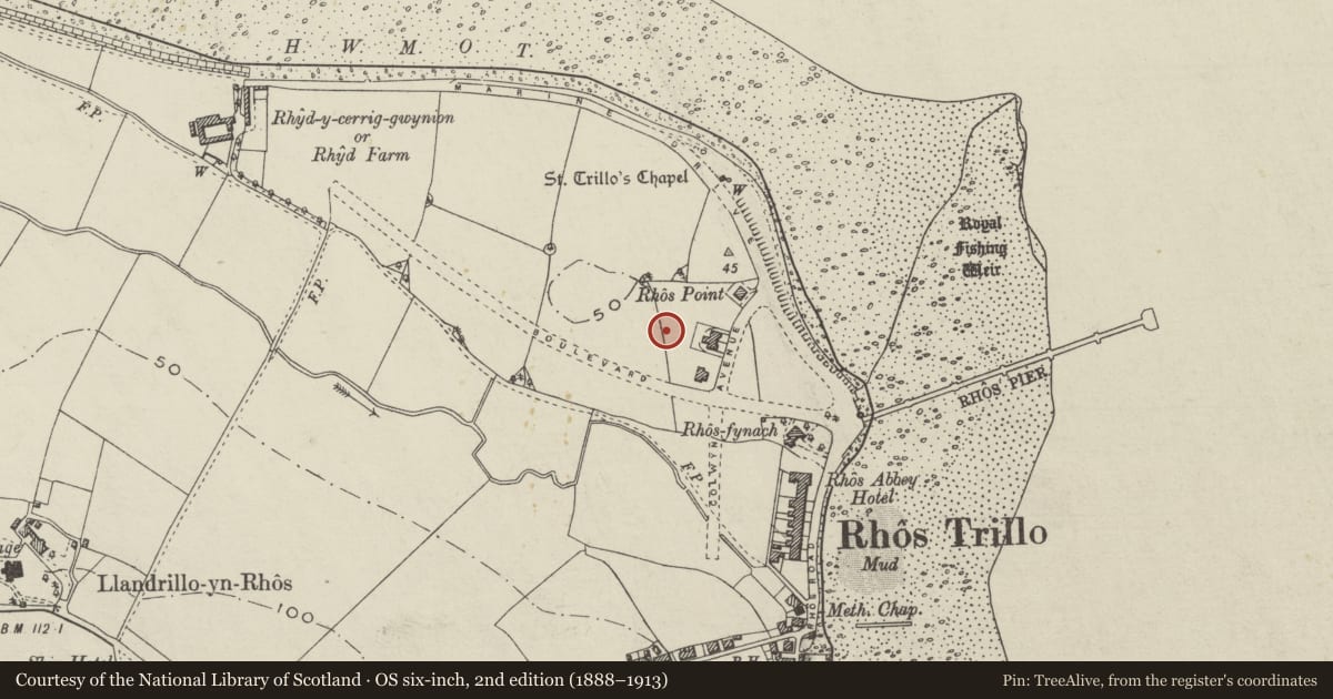
Slide toward Today to fade the historical sheet and see the modern map underneath.
David Rumsey Map Collection, Stanford LibrariesDavid Rumsey Map Collection, Stanford LibrariesDavid Rumsey Map Collection, Stanford LibrariesLlyfrgell Genedlaethol Cymru – The National Library of WalesNational Library of Scotland
5 historical maps cover this location, the earliest the 1795 map "To Sir Watkin Williams-Wynn Bart ... the map of the six counties of North Wales is most humbly inscribed by his obedient humble servant" (Llyfrgell Genedlaethol Cymru – The National Library of Wales).
Historical maps covering this location
- 1795 · To Sir Watkin Williams-Wynn Bart ... the map of the six counties of North Wales is most… (Llyfrgell Genedlaethol Cymru – The National Library of Wales)
- 1883 · Watershed map England, Wales 3. (David Rumsey Map Collection, Stanford Libraries)
- 1898 · 95 Rhyl (Hills) (David Rumsey Map Collection, Stanford Libraries)
- 1901 · Sheet 9 and 10. (David Rumsey Map Collection, Stanford Libraries)
- 1930 · OS Popular Edition 1919-1947 (National Library of Scotland)
Cadw's description
History
Built in 1932, by North and Padmore architects, of Llanfairfechan, for a Mr Normal Taylor.
Exterior
Roughcast render with slate roof, projecting on plain chamfered angle brackets. Brick end wall and axial stacks, the axial stack stepped in profile. Windows throughout are metal casements, with slightly swept hood moulds. Elevation facing street has narrow central gable, with steep, chamfered arch to doorway in the right hand side, the main roofline swept down over a garage advanced agaisnt the left hand side of the gable. Narrow round-arched light in ground floor of gable, and small 2-light casement in the apex. 2-light casement window to ground floor to right of central gable. 3 and 4-light casement windows in gable end. Rear elevation has French doors beneath steep porch gable carried on struts to left, and central 4-light casement window. Above this, the roof-line is pushed up as a catslide dormer with plain angle brackets, and windows of 2 and 4-lights immediately below its eaves. To the right, the main roof line continues down over an outshut which wraps under this catslide dormer.
Reason for designation
An excellent example of the domestic architecture of its period, and of the work of North and Padmore.
Nearby in the register
- 4 Trillo AvenueDomesticunder 1 mi
- United Reformed ChurchReligious, Ritual and Funeraryunder 1 mi
- St Trillo's ChapelReligious, Ritual and Funeraryunder 1 mi
- Former Pier Entrance BuildingRecreationalunder 1 mi
Other entries of the same register within about three miles of this one, by straight line.