Cof Cymru: National Historic Assets of Wales · Wales
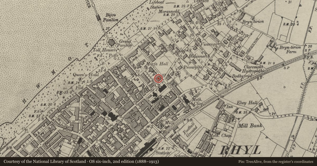
Bath Street
Rhyl, Denbighshire, Wales
A Grade II listed building in Rhyl, Denbighshire, designated on 14 February 1994.
The record
- Designation
- Listed building, Grade II
- Broad class
- Domestic
- Date of designation
- 14 February 1994
- Community
- Rhyl
- Unitary authority
- Denbighshire
- Country
- Wales
- Coordinates
- 53.32168, -3.48793
- Cadw reference
- 14310
Slide toward Today to fade the historical sheet and see the modern map underneath.
David Rumsey Map Collection, Stanford LibrariesDavid Rumsey Map Collection, Stanford LibrariesNational Library of ScotlandDavid Rumsey Map Collection, Stanford LibrariesNational Library of Scotland
5 historical maps cover this location, the earliest the 1883 map "Watershed map England, Wales 3." (David Rumsey Map Collection, Stanford Libraries).
Historical maps covering this location
- 1883 · Watershed map England, Wales 3. (David Rumsey Map Collection, Stanford Libraries)
- 1898 · 95 Rhyl (Hills) (David Rumsey Map Collection, Stanford Libraries)
- 1901 · Sheet 9 and 10. (David Rumsey Map Collection, Stanford Libraries)
- 1930 · OS Popular Edition 1919-1947 (National Library of Scotland)
- 1963 · Map No. 36 - Local Government Commission for Wales : [Definitive maps showing proposed… (National Library of Scotland)
Cadw's description
Location
On the corner of Bath Street, opposite the Church of Saint Thomas.
Exterior
Row of 4 houses, similar in plan to Nos 35-41 Russell Road, and probably designed and built at the same time, c1877. Yellow-brick with painted stone and red-brick dressings (roughcast render to No 43). Slate roof with axial and end wall stacks, some truncated. Two storeys with attics, symmetrically planned with advanced outer gables and short side gabled wings housing entrances to No 43 and No 29 Bath Street. Main gables have 2 storeyed canted bay windows with painted stone plain cornices, and terracotta panels inset below first floor windows. Round arched windows in gable apexes, with keystones, red-brick hood-mould and impost bands. Sill bands to first floor and attic storey continue across the facade. Central range has doorways in angle with gables to either side, in porches with entablature continuing across rectangular bay windows, which are divided as tripartite sashes. The entablature carries cast-iron brattishing. Single windows over the doors, and paired windows above the bays, all round-arched and linked by red-brick hood mould and impost band which continues across the principal facades. Paired gabled dormer windows to centre above, with round-arched windows and pierced bargeboards with finials. Deep moulded eaves cornice to central range, and plain bargeboards to main gables. Return elevation to Bath Street has wide gable with canted bay window to ground floor, and round-arched windows in each floor above.
Reason for designation
An interesting design in which the individual properties are subordinated to the architectural composition of the terrace; the design is almost identical to that used in Nos 35-41 Russell Road, but the decorative vocabulary, which survives almost intact, is developed to exploit brickwork, comparing with the plasterwork decoration of the adjacent row. The buildings form part of a group of villas typical of east Rhyl’s development in the 1870s.
Part of an important group of buildings around the Church of the Holy Trinity and the Church of Saint Thomas.
Nearby in the register
- Bath StreetDomesticunder 1 mi
- 41 Russell RoadDomesticunder 1 mi
- Bath StreetDomesticunder 1 mi
- 39 Russell RoadDomesticunder 1 mi
Other entries of the same register within about three miles of this one, by straight line.