Cof Cymru: National Historic Assets of Wales · Wales
Former Mission Hall
Pontypridd, Rhondda Cynon Taff, Wales
A Grade II listed building in Pentrebach, Pontypridd, Rhondda Cynon Taff, designated on 16 February 1993.
The record
- Designation
- Listed building, Grade II
- Broad class
- Religious, Ritual and Funerary
- Date of designation
- 16 February 1993
- Locality
- Pentrebach
- Town
- Pontypridd
- Community
- Pontypridd
- Unitary authority
- Rhondda Cynon Taff
- Country
- Wales
- Coordinates
- 51.60271, -3.33105
- Cadw reference
- 13535
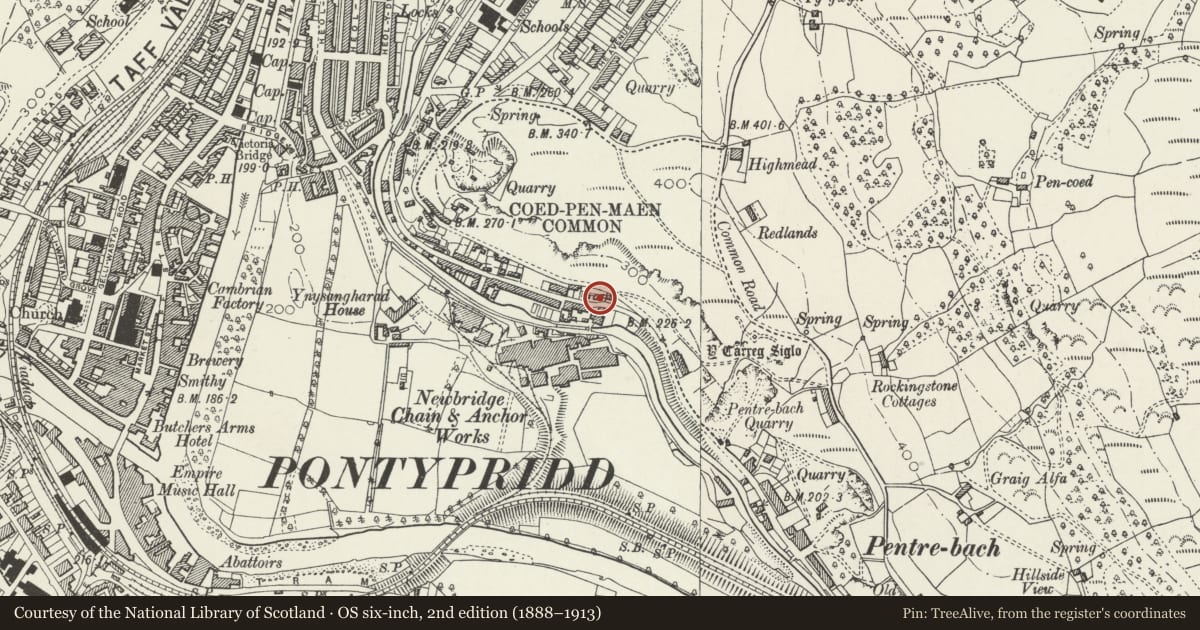
Slide toward Today to fade the historical sheet and see the modern map underneath.
David Rumsey Map Collection, Stanford LibrariesNational Library of ScotlandDavid Rumsey Map Collection, Stanford LibrariesDavid Rumsey Map Collection, Stanford LibrariesDavid Rumsey Map Collection, Stanford Libraries
5 historical maps cover this location, the earliest the 1636 map "Cornubia : Devonia, Somersetus, Dorcestria, Wiltonia, Glocestria ..." (David Rumsey Map Collection, Stanford Libraries).
Historical maps covering this location
- 1636 · Cornubia : Devonia, Somersetus, Dorcestria, Wiltonia, Glocestria ... (David Rumsey Map Collection, Stanford Libraries)
- 1637 · The fourth table of England. Cornub. Devonia, Somerset etc. (David Rumsey Map Collection, Stanford Libraries)
- 1865 · England and Wales. England No. 6. (David Rumsey Map Collection, Stanford Libraries)
- 1895 · Sheet 11. Ordnance Survey of England and Wales. (David Rumsey Map Collection, Stanford Libraries)
- 1963 · Map No. 14 - Local Government Commission for Wales : [Definitive maps showing proposed… (National Library of Scotland)
Cadw's description
Location
On the E side of the River Taff, beyond Ynysangharad Park and the A470, and below Coed-pen-maen Common. Set high above the road with rubble forecourt wall. The rear elevation is below Merthyr Road.
History
Dated 1873. Built by the Brown Lenox Chain Works to provide a place of worship for its staff. The Brown Lenox Works was internationally renowned and was one of the few highly developed engineering industries in South Wales. The Mission Hall is shown on Ordnance Survey map as a Sunday School.
Exterior
Rectangular chapel of snecked rock-faced stone and hipped slate roof with boarded eaves. The openings are round-headed with voussoirs, with replacement small-pane windows that are less deep than the original windows although the original stone sills are retained. The entrance is to the R (SE) end which has 2 windows flanking a central doorway, which is now partly infilled with a modern square-headed door. Above this is a shaped freestone plaque inscribed "Chain Works Mission Hall AD 1873". The side walls are 3-window. The L-hand side of the rear elevation has a blocked opening.
Interior
Interior is converted for domestic use.
Reason for designation
Listed, despite modern alterations, for its special interest as an unusual example of a chapel built exclusively for the workforce of a single company, in this case the famous Brown Lenox Works.
Nearby in the register
- Bridge over Glamorganshire Canal W of Newbridge Chainworks basinTransportunder 1 mi
- Newbridge Chainworks Canal Basin on the Glamorganshire CanalTransportunder 1 mi
- Lock Chambers 31 & 32 with attached walls, Glamorganshire CanalTransportunder 1 mi
- Ring Cairn and Two Standing Stones on Coedpenmaen CommonRing Cairnunder 1 mi
Other entries of the same register within about three miles of this one, by straight line.