Cof Cymru: National Historic Assets of Wales · Wales
Tinkins Hall (former Cory Institute)
St. Nicholas and Bonvilston, Vale of Glamorgan, Wales
A Grade II listed building in St Nicholas, St. Nicholas and Bonvilston, Vale of Glamorgan, designated on 17 February 1992.
The record
- Designation
- Listed building, Grade II
- Broad class
- Religious, Ritual and Funerary
- Date of designation
- 17 February 1992
- Date of amendment
- 29 March 2019
- Welsh name
- Neuadd Tinkins (Sefydliad Cory gynt)
- Locality
- St Nicholas
- Community
- St. Nicholas and Bonvilston
- Unitary authority
- Vale of Glamorgan
- Country
- Wales
- Coordinates
- 51.45997, -3.31084
- Cadw reference
- 13463
Slide toward Today to fade the historical sheet and see the modern map underneath.
David Rumsey Map Collection, Stanford LibrariesDavid Rumsey Map Collection, Stanford LibrariesDavid Rumsey Map Collection, Stanford LibrariesDavid Rumsey Map Collection, Stanford LibrariesDavid Rumsey Map Collection, Stanford Libraries
5 historical maps cover this location, the earliest the 1636 map "Cornubia : Devonia, Somersetus, Dorcestria, Wiltonia, Glocestria ..." (David Rumsey Map Collection, Stanford Libraries).
Historical maps covering this location
- 1636 · Cornubia : Devonia, Somersetus, Dorcestria, Wiltonia, Glocestria ... (David Rumsey Map Collection, Stanford Libraries)
- 1637 · The fourth table of England. Cornub. Devonia, Somerset etc. (David Rumsey Map Collection, Stanford Libraries)
- 1865 · England and Wales. England No. 6. (David Rumsey Map Collection, Stanford Libraries)
- 1898 · 263 Cardiff (Hills) (David Rumsey Map Collection, Stanford Libraries)
- 1913 · Sheet 110. Cardiff & Mouth of the Severn. (David Rumsey Map Collection, Stanford Libraries)
Cadw's description
Location
Located on the S side of the Cardiff Road (A48), opposite Smiths Row.
History
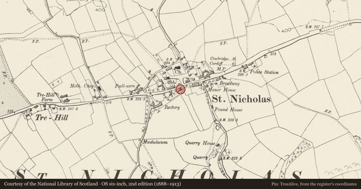
Built 1896-7 by Lansdowne and Griggs Architects of Newport, along with the attached Church House as the Cory Institute. Both buildings were designed and constructed together as a Temperance Institute with Mission Hall, Coffee Tavern and Temperance Institute and Rooms and are shown on the 2nd edition O.S. map, surveyed in 1898. The Cory family were well known local industrialists, philanthropists and supporters of the Temperance movement. Rear extension added to the Hall 1992-95 in materials to match the Hall and House. Renamed Tinkins Hall in 2017.
Exterior
In the Arts and Crafts style. Single storey hall.
Buttressed front elevation in coursed liassic rubble. Red tiled roof with over-hanging eaves and red brick stacks with corbelled cap and string course. Louvered ventilator at centre of hall roof. Clay tile-hanging to upper portion of east gable with band of fish-scale tiling. Brick stacks.
Hall has projecting gabled entrance porch to east end of front elevation with cross-frame window set in a bracketed architrave and tile hanging above; three camber-headed tripartite windows beyond to main elevation of hall with small panes to top.
In front of the hall are iron railings with stone gate piers and gabled caps. Later extension to rear of hall with gabled bay to E side and round-headed arcade to S of hall.
Interior
Hall open plan with 4-bay roof, king post with curved supporting struts and arcaded collar with round headed bracing and under- hanging end finials. Base of trusses arched and sat on corbels. Diagonal boarding to the ceiling set into square bays divided by purlins and trusses and intermediate common rafters. Double panelled door with plain surround at NE to entrance porch. Dado panelling. Platform at W end with door in former window adjacent.
Reason for designation
Included for its special architectural interest as a well designed and largely well preserved House and Church Hall in the Arts & Crafts style, displaying careful use of materials and design. It is also important for its historic significance as a key building within the centre of St. Nicholas in a prominent and important location.
Nearby in the register
- Church Hall House (former Cory Institute)Domesticunder 1 mi
- Smiths Row (also known as Blcksmiths Cottages)Domesticunder 1 mi
- GPO Pillar on corner with Road to St Nicholas' ChurchCommunicationsunder 1 mi
- Telephone Call-box on corner with road to St Nicholas' ChurchCommunicationsunder 1 mi
Other entries of the same register within about three miles of this one, by straight line.