Cof Cymru: National Historic Assets of Wales · Wales
Barn at Court Farm
Penllyn, Vale of Glamorgan, Wales
A Grade II listed building in Llansannor, Cowbridge, Penllyn, Vale of Glamorgan, designated on 27 February 1992.
The record
- Designation
- Listed building, Grade II
- Broad class
- Agriculture and Subsistence
- Date of designation
- 27 February 1992
- Locality
- Llansannor
- Town
- Cowbridge
- Community
- Penllyn
- Unitary authority
- Vale of Glamorgan
- Country
- Wales
- Coordinates
- 51.48663, -3.44977
- Cadw reference
- 13461
Slide toward Today to fade the historical sheet and see the modern map underneath.
David Rumsey Map Collection, Stanford LibrariesDavid Rumsey Map Collection, Stanford LibrariesDavid Rumsey Map Collection, Stanford LibrariesDavid Rumsey Map Collection, Stanford LibrariesDavid Rumsey Map Collection, Stanford Libraries
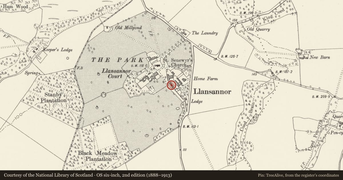
5 historical maps cover this location, the earliest the 1636 map "Cornubia : Devonia, Somersetus, Dorcestria, Wiltonia, Glocestria ..." (David Rumsey Map Collection, Stanford Libraries).
Historical maps covering this location
- 1636 · Cornubia : Devonia, Somersetus, Dorcestria, Wiltonia, Glocestria ... (David Rumsey Map Collection, Stanford Libraries)
- 1637 · The fourth table of England. Cornub. Devonia, Somerset etc. (David Rumsey Map Collection, Stanford Libraries)
- 1865 · England and Wales. England No. 6. (David Rumsey Map Collection, Stanford Libraries)
- 1897 · 262 Pontypridd (Hills) (David Rumsey Map Collection, Stanford Libraries)
- 1897 · 262 Pontypridd (Outline) (David Rumsey Map Collection, Stanford Libraries)
Cadw's description
Location
Court Farm lies to east of Llansannor Court; the barn is situated on the west side of the farmyard with the former Granary and Cartshed attached on the right. Reached approximately 4km north of Cowbridge.
History
Court Farm was built as the Home Farm to the largely C16 and C17 Llansannor Court and the barn may be partly contemporary with the later parts of the house. Its generous proportions and roof structure, however, suggest the C18 which is also the date for the farmhouse. The barn is one of the largest surviving in the Vale of Glamorgan.
Exterior
Substantial roughly coursed local limestone rubble built corn barn with renewed Welsh slate roof and high gable parapets. Unusual, 4-centred arch barn door opening to centre with voussoirs, rear opening is blocked, slit ventilators, including three in either gable. Inserted to left of the doors are a
4-pane window and a loft door above, both with brick jambs; blocked door near battered left gable end. Other windows are in the process of being added and there are roof-lights on both slopes of the renewed roof. Long low range stepped down to south.
Interior
Lofty 7-bay barn with central threshing floor. When listed (1992) it had largely original collared roof trusses; the lower collars having been replaced or added with metal bolts, three tiers of purlins. The barn has, however, been re-roofed in 2003; the apparently C18 main timbers have been reused but both the ties and the collars are now all bolted. The tallet for the hayloft survived at the south end at the time of inspection (September 2003), but the barn was in the process of conversion.
Reason for designation
Included for its special interest as an unusually large and possibly C17 barn surviving in the Vale of Glamorgan. It also has group value with Llansannor Court and the Church of St. Senwyr.
Nearby in the register
- Former Cartshed and Granary at Court FarmDomesticunder 1 mi
- Llansannor CourtDomesticunder 1 mi
- West Wing of Llansannor Court (aka Court Cottage)Domesticunder 1 mi
- Cross in Churchyard of Church of St. SenwyrReligious, Ritual and Funeraryunder 1 mi
Other entries of the same register within about three miles of this one, by straight line.