Cof Cymru: National Historic Assets of Wales · Wales
Canal Museum
Llangollen, Denbighshire, Wales
A Grade II listed building in Llangollen, Denbighshire, designated on 22 December 1989.
The record
- Designation
- Listed building, Grade II
- Broad class
- Transport
- Date of designation
- 22 December 1989
- Community
- Llangollen
- Unitary authority
- Denbighshire
- Country
- Wales
- Coordinates
- 52.97195, -3.17053
- Cadw reference
- 1225
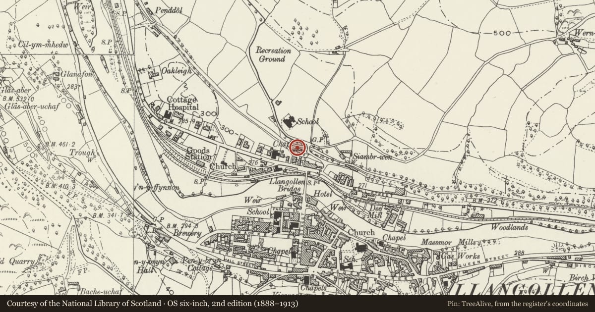
Slide toward Today to fade the historical sheet and see the modern map underneath.
David Rumsey Map Collection, Stanford LibrariesDavid Rumsey Map Collection, Stanford LibrariesDavid Rumsey Map Collection, Stanford LibrariesDavid Rumsey Map Collection, Stanford LibrariesLlyfrgell Genedlaethol Cymru – The National Library of Wales
5 historical maps cover this location, the earliest the 1795 map "To Sir Watkin Williams-Wynn Bart ... the map of the six counties of North Wales is most humbly inscribed by his obedient humble servant" (Llyfrgell Genedlaethol Cymru – The National Library of Wales).
Historical maps covering this location
- 1795 · To Sir Watkin Williams-Wynn Bart ... the map of the six counties of North Wales is most… (Llyfrgell Genedlaethol Cymru – The National Library of Wales)
- 1883 · Watershed map England, Wales 3. (David Rumsey Map Collection, Stanford Libraries)
- 1898 · 121 Wrexham (Hills) (David Rumsey Map Collection, Stanford Libraries)
- 1898 · 121 Wrexham (Outline) (David Rumsey Map Collection, Stanford Libraries)
- 1901 · Sheet 9 and 10. (David Rumsey Map Collection, Stanford Libraries)
Cadw's description
Location
On the towpath immediately to W of the modern road bridge over the canal. Land falls away steeply to rear.
History
The 6-mile long Llangollen canal had been proposed as early as 1791 as a branch of the canal that was to link Rivers Mersey and Dee with the River Severn. The Act was passed in 1793 with this section constructed under the direction of Thomas Telford. The purpose of the Llangollen branch was primarily that of a feeder to supply the main Ellesmere Canal drawing water off the River Dee at Horseshoe Falls. Work was begun in 1804 and completed in 1808 and in addition provided transport to the slate quarries and the limestone works. In 1846 it became part of the Shropshire Union Railways Company but the following year was taken over by the LNWR. Transport on the canal diminished in late C19 with arrival of the railways and then ceased by 2nd World War. The canal was only kept open because of its importance as a supplier of water to the Shropshire Union Canal, the steam engines at Chester Station and some houses in the Crewe area. Over 6 million gallons a day are metered into the canal at Horseshoe Falls.
This rubble warehouse building at the Llangollen Wharf probably dates from the construction of the canal (1804-8). Later heightened and extended in red brick.
Exterior
2-storey to centre with slate roof and dentil brick cornice. Full height double boarded doors to centre; window to left below bucket rack. Rubble lean-to at the left with boarded door under cambered arch, modern window on left end. Single storey brick range to right with broad camber headed entry and modern dormer. Modern ticket office to right end and casement windows amd modern additions to rear. Crane on wharf quay.
Reason for designation
T Pellow and P Bowen, "Canal to Llangollen", (1988).
Nearby in the register
- 4 Abbey SquareDomesticunder 1 mi
- 3 Abbey SquareDomesticunder 1 mi
- 2 Abbey SquareDomesticunder 1 mi
- 1 Abbey SquareDomesticunder 1 mi
Other entries of the same register within about three miles of this one, by straight line.