Cof Cymru: National Historic Assets of Wales · Wales
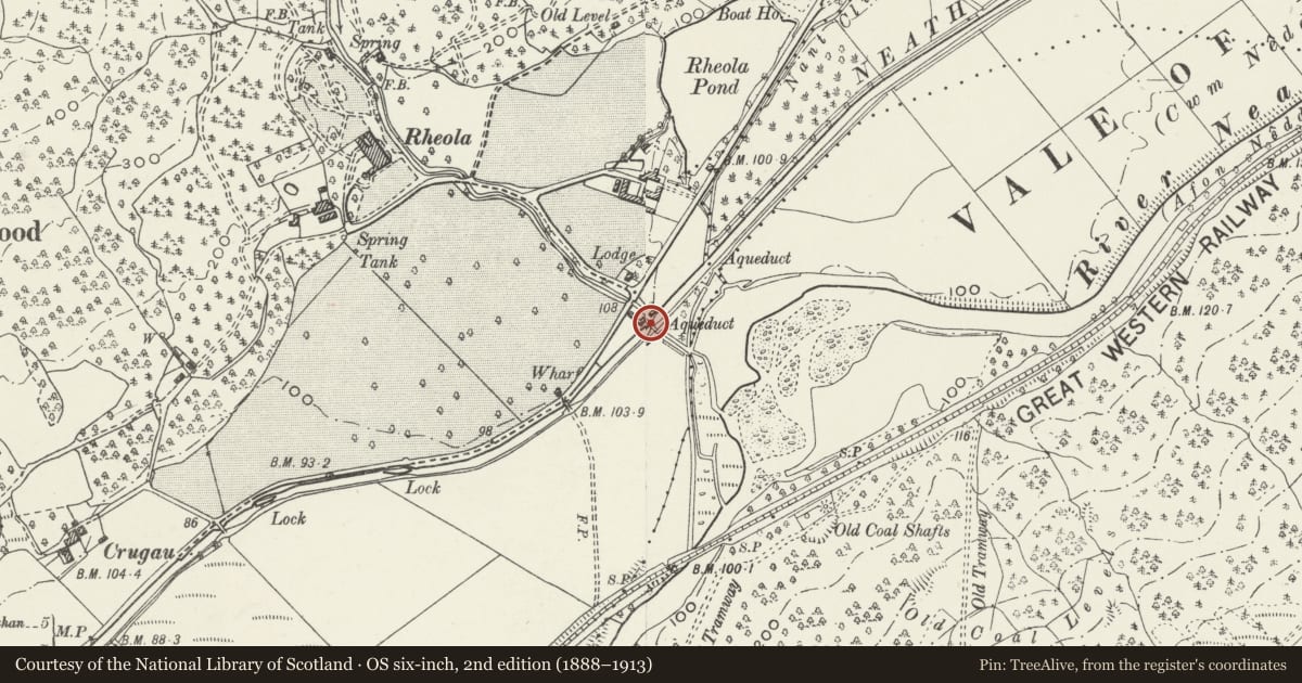
Rheola Brook Aqueduct
Glynneath, Neath Port Talbot, Wales
A Grade II listed building in Rheola, Neath, Glynneath, Neath Port Talbot, designated on 28 March 1990.
The record
- Designation
- Listed building, Grade II
- Broad class
- Water Supply and Drainage
- Date of designation
- 28 March 1990
- Locality
- Rheola
- Town
- Neath
- Community
- Glynneath
- Unitary authority
- Neath Port Talbot
- Country
- Wales
- Coordinates
- 51.72250, -3.67747
- Cadw reference
- 11854
Slide toward Today to fade the historical sheet and see the modern map underneath.
David Rumsey Map Collection, Stanford LibrariesDavid Rumsey Map Collection, Stanford LibrariesDavid Rumsey Map Collection, Stanford LibrariesDavid Rumsey Map Collection, Stanford LibrariesDavid Rumsey Map Collection, Stanford Libraries
5 historical maps cover this location, the earliest the 1636 map "Cornubia : Devonia, Somersetus, Dorcestria, Wiltonia, Glocestria ..." (David Rumsey Map Collection, Stanford Libraries).
Historical maps covering this location
- 1636 · Cornubia : Devonia, Somersetus, Dorcestria, Wiltonia, Glocestria ... (David Rumsey Map Collection, Stanford Libraries)
- 1637 · The fourth table of England. Cornub. Devonia, Somerset etc. (David Rumsey Map Collection, Stanford Libraries)
- 1830 · V.3:11-15:XV. Britisches Reich. A. Kon: England. b. Frstenthum Wales: Shire: 37-40 (David Rumsey Map Collection, Stanford Libraries)
- 1865 · England and Wales. England No. 6. (David Rumsey Map Collection, Stanford Libraries)
- 1898 · 231 Merthyr Tydfil (Hills) (David Rumsey Map Collection, Stanford Libraries)
Cadw's description
Location
Situated crossing the Neath Canal just S of the B4242 and opposite the entrance to Rheola House.
History
Cast-iron former aqueduct built to carry the Rheola Brook over the Neath Canal, now dry and used as footbridge. Presumably of c1830 and made at the Neath Abbey Ironworks.
Exterior
Cast-iron aqueduct made up of massive cast-iron pieces, two side pieces with decorated outer faces and six base pieces. The sides have eleven thin Roman Doric half-columns as decoration. Broad channel of joined single massive pieces.
Bridge is set between rubble stone piers of squared stones, each pier with triangular-section faces. Channel to N is between parapets with cobbled channel and two further triangular-faced piers. To S channel slopes down slightly with parapets which are then cut for access ramps down to canal.
Reason for designation
Included for its special historic interest as a fine example of the remarkable cast-iron aqueducts made at Neath Abbey ironworks for the Neath Canal.
Nearby in the register
- Rheola overbridge on Neath CanalTransportunder 1 mi
- Stables and Coach House at Rheola HouseDomesticunder 1 mi
- Icehouse at Rheola HouseDomesticunder 1 mi
- Rheola HouseDomesticunder 1 mi
Other entries of the same register within about three miles of this one, by straight line.