Cof Cymru: National Historic Assets of Wales · Wales
One of Four Linked Outbuildings forming Courtyard at Llanfair
Llandysul, Ceredigion, Wales
A Grade II listed building in Llanfair, Llandysul, Ceredigion, designated on 13 January 1993.
The record
- Designation
- Listed building, Grade II
- Broad class
- Domestic
- Date of designation
- 13 January 1993
- Locality
- Llanfair
- Community
- Llandysul
- Unitary authority
- Ceredigion
- Country
- Wales
- Coordinates
- 52.04476, -4.28623
- Cadw reference
- 10612
Slide toward Today to fade the historical sheet and see the modern map underneath.
David Rumsey Map Collection, Stanford LibrariesDavid Rumsey Map Collection, Stanford LibrariesDavid Rumsey Map Collection, Stanford LibrariesDavid Rumsey Map Collection, Stanford LibrariesDavid Rumsey Map Collection, Stanford Libraries
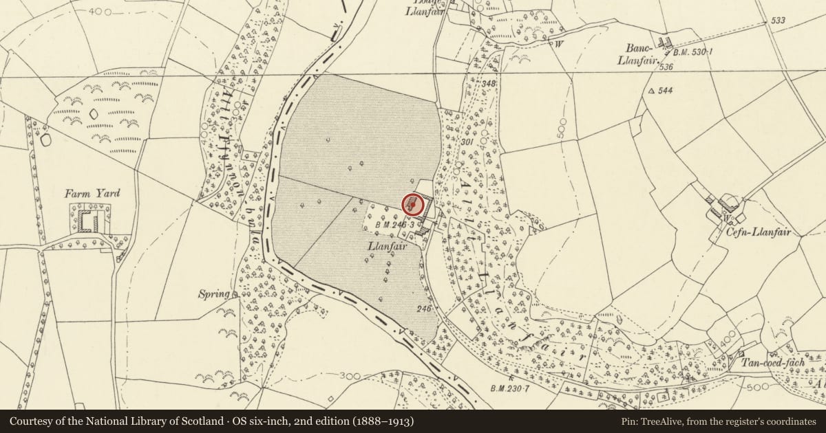
5 historical maps cover this location, the earliest the 1830 map "V.3:11-15:XV. Britisches Reich. A. Kon: England. b. Frstenthum Wales: Shire: 37-40" (David Rumsey Map Collection, Stanford Libraries).
Historical maps covering this location
- 1830 · V.3:11-15:XV. Britisches Reich. A. Kon: England. b. Frstenthum Wales: Shire: 37-40 (David Rumsey Map Collection, Stanford Libraries)
- 1860 · 41. Caermathen. (David Rumsey Map Collection, Stanford Libraries)
- 1891 · Sheet 10. Ordnance Survey of England and Wales. . (David Rumsey Map Collection, Stanford Libraries)
- 1899 · 194 Llangranog (Hills) (David Rumsey Map Collection, Stanford Libraries)
- 1901 · Sheet 14. (David Rumsey Map Collection, Stanford Libraries)
Cadw's description
Location
Situated close to N of the house.
Exterior
Dated TT 1797 and TMT 1847 on E range. Large 4-sided court-yard of farm-buildings and estate houses built for the Thomas family of Llanfair. Rubble stone with slate roofs, mostly 2-storey. E and N ranges have even roof-line, hipped at outer NE angle though interior of E range now open to roof. E range has camber-headed doors and small windows, all with stone voussoirs, one upper loading door towards S end and concrete block lean-to against centre. Arched cartshed entry at N end. N range has 2 similar cart entries with windows above, by NE angle, then tall barn-entry with cambered arch and then 4 well-spaced bays, alternate doors and windows below, 3 windows and a loading door above. Barn has 9-bay collar truss roof and is lofted for 4 bays. The roofs are similar throughout the N and E ranges, suggesting a single build c1847.
The W range also seems mid C19 with lower 2-storey outbuilding at NW linking to a big block of 2-storey estate housing. The outbuildings have 4 bays of pig-sties, an enclosed section and cartshed arch in NW angle. The house range appears to have comprised three 2-window houses with close-spaced arched windows and doors, ashlar voussoirs, one door now a window, and then 2 broader bays to left with arched cart-entries below and similar windows above. Cart entries are now glazed. Windows are small-paned narrow casements with single-pane fanlights above. One stone stack.
Adjoining to S is gabled stone gateway with dove-holes, big ashlar arch and wrought iron gates, aligned with similar entrance gateway at SE angle of yard.
Single-storey S range is the only one with clear evidence of 2 periods of building. The upper, left end of 6 stone-voussoir arches has W end straight joint and older pegged collar trusses. Two arches blocked. Attached SE gabled entry to court, arched with coped gable linked to square stone stack each side. Original gates now preserved on end wall of E range. S range continued W with arched window (brick-arched) door, tall arched door and arched cart-entry, with stone voussoirs, and then 2 small doors. Range appears to have been stable, loose-box, coach-house and tack-room.
Reason for designation
Group value with the house at Llanfair. A very large estate farm courtyard, marked in its final form on 1891 O.S, but only parts on c1840 and 1845 estate plan in National Library of Wales.
Nearby in the register
- One of Four Linked Outbuildings forming Courtyard at LlanfairDomesticunder 1 mi
- One of Four Linked Outbuildings forming Courtyard at LlanfairDomesticunder 1 mi
- One of Four Linked Outbuildings forming Courtyard at LlanfairDomesticunder 1 mi
- Llanfair including attached W Range.Domesticunder 1 mi
Other entries of the same register within about three miles of this one, by straight line.