Sites and Monuments Record · Ireland
Walled garden
Bewley, County Waterford, Ireland
The record
- Townland
- Bewley
- County
- Waterford
- Country
- Ireland
- First-edition OS map
- Indicated
- Latest-edition OS map
- Indicated
- Coordinates
- 52.11205, -7.82366
- SMR number
- WA029-024004-
Slide toward Today to fade the historical sheet and see the modern map underneath.
David Rumsey Map Collection, Stanford LibrariesDavid Rumsey Map Collection, Stanford LibrariesDavid Rumsey Map Collection, Stanford LibrariesDavid Rumsey Map Collection, Stanford Libraries
4 historical maps cover this location, the earliest the 1790 map "Composite: Ireland." (David Rumsey Map Collection, Stanford Libraries).
Historical maps covering this location
- 1790 · Composite: Ireland. (David Rumsey Map Collection, Stanford Libraries)
- 1882 · Ireland (southern half). (David Rumsey Map Collection, Stanford Libraries)
- 1891 · Ireland 16 (David Rumsey Map Collection, Stanford Libraries)
- 1904 · Sheet 13. (David Rumsey Map Collection, Stanford Libraries)
This record in the National Monuments Service's Historic Environment Viewer ↗
The National Monuments Service's description
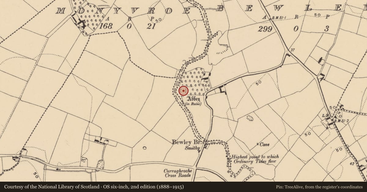
Situated on the floodplain of the S-N Finisk River, on the E bank with the river c. 20m to the W. This is reputedly a house of the Knights Templar (Gwynn and Hadcock 1970, 329), but there are no medieval sources. Attached to N of the church (WA029-024001-) is a rectangular enclosure (dims. 62m E-W; 40m N-S) defined by the remains of a stone wall (Wth c. 1m; max. H c. 3m at NE angle), with evidence of a wall-walk and slight traces of an outer fosse (Wth 3.5m; D 0.2m; L 23m) at the E end of the N wall. This enclosure was divided by a N-S masonry wall, now reduced to the foundations. The enclosure functioned as an orchard but it has a medieval origin, and buildings (WA029-024002-) within it were removed by 1898 (Power 1898a, 95) . There is a bullaun stone (WA029-024005-) but an inscribed stone (WA029-024006-) found c. 1890 is lost without record. (O'C. Redmond 1895, 154; Power 1898a, 94-5)
Gwynn, A. and Hadcock, R. N. (1970) (reprint 1988) Medieval religious houses in Ireland. Irish Academic Press, Dublin.
O'C. Redmond, G. (1895) Notes on the history, antiquities, archaeological remains and legends connected with the western end of the county Waterford, part II.WAJ 1, 119-32, 147-61.
Power, Rev. P. (1898a) Ancient ruined churches of Co. Waterford, WAJ 4, 83-95, 195-219.
Compiled by: Michael Moore
Date of upload: 26 July 2011
References
Redmond, G. O'Connell 1895 Notes on the history, antiquities, archaeological remains and legends connected with the western end of the County Waterford. Waterford and South East of Ireland Archaeological Journal 1, 119-32, 147-61.
Power, Rev. P. 1898a Ancient ruined churches of Co. Waterford. Waterford and South East of Ireland Archaeological Journal 4, 83-95, 195-219.
Gwynn, A. and Hadcock, R.N. 1970 (Reprint 1988) Medieval religious houses of Ireland. Dublin. Irish Academic Press.
Nearby in the register
- Buildingunder 1 mi
- Graveyardunder 1 mi
- Bullaun stoneunder 1 mi
- Inscribed stoneunder 1 mi
Other entries of the same register within about three miles of this one, by straight line.