Sites and Monuments Record · Ireland
Church
Kilmore (Clonoulty Par.), County Tipperary South, Ireland
The record
- Townland
- Kilmore (Clonoulty Par.)
- County
- Tipperary South
- Country
- Ireland
- First-edition OS map
- Kilmore Church (in Ruins)
- Latest-edition OS map
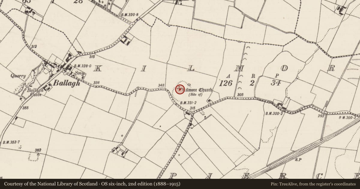
- Kilmore Church (Site of)
- Coordinates
- 52.58953, -7.97671
- SMR number
- TS052-004002-
Slide toward Today to fade the historical sheet and see the modern map underneath.
David Rumsey Map Collection, Stanford LibrariesDavid Rumsey Map Collection, Stanford LibrariesDavid Rumsey Map Collection, Stanford LibrariesDavid Rumsey Map Collection, Stanford Libraries
4 historical maps cover this location, the earliest the 1790 map "Composite: Ireland." (David Rumsey Map Collection, Stanford Libraries).
Historical maps covering this location
- 1790 · Composite: Ireland. (David Rumsey Map Collection, Stanford Libraries)
- 1869 · Ireland. (David Rumsey Map Collection, Stanford Libraries)
- 1891 · Ireland 16 (David Rumsey Map Collection, Stanford Libraries)
- 1904 · Sheet 13. (David Rumsey Map Collection, Stanford Libraries)
This record in the National Monuments Service's Historic Environment Viewer ↗
The National Monuments Service's description
In grassland, on a gentle SE-facing slope just below the top of a hill with good views to S and E only. According to Gwynn and Hadcock (1988, 394) this was the location of a monastery known as 'Kill-mor-aradhthire'. In the visitation books of the Diocese of Cashel the church is referred to as 'Kilmore Chapelry' which suggests that it was a chapel of ease, possibly to the parish church of Athassel (White 1892, 53-4). Kilmore is mentioned in the Extents of Irish Monastic Possessions in 1541 (Ó Cearbhaill 2007, 172). According to the OS Letters 'The site of the old Church of Kilmore is to be seen in the middle of a green field...but no part of the walls is now standing and even the graveyard has disappeared. Mr. Cooper has erected an enclosure for sheep of the stones of the old Church' (O'Flanagan 1930, vol. 1, 93). All that remains are the low wall-footings of a small rectangular church (int. dims. approx. 6m N-S; 15m E-W; wall-footings T 2.5m; ext. dims. 11m N-S; 23m E-W) located in the W quadrant of a large circular enclosure (TS052-004001-).
Compiled by: Jean Farrelly
Date of upload: 26 August 2011
References
Gwynn, A. and Hadcock, R.N. 1970 (Reprint 1988) Medieval religious houses of Ireland. Dublin. Irish Academic Press.
White, J.D. 1892 Anthologia Tipperariensis. Cashel.
O'Flanagan, Rev. M. (Compiler) 1930 Letters containing information relative to the antiquities of the county of Tipperary collected during the progress of the Ordnance Survey in 1840. Bray.
Ó Cearbhaill, P. 2007 Logainmneacha na hÉireann II: Cill i logainmneacha Co. Thiobraid Árann. The Stationery Office. Dublin.
Nearby in the register
- Ecclesiastical enclosureunder 1 mi
- Enclosureunder 1 mi
- Moated siteunder 1 mi
- Castle - tower houseunder 1 mi
Other entries of the same register within about three miles of this one, by straight line.