Sites and Monuments Record · Ireland
Settlement cluster
Treanmacmurtagh, County Sligo, Ireland
The record
- Townland
- Treanmacmurtagh
- County
- Sligo
- Country
- Ireland
- First-edition OS map
- Not indicated
- Latest-edition OS map
- Not indicated
- Coordinates
- 54.05459, -8.41325
- SMR number
- SL040-079001-
Slide toward Today to fade the historical sheet and see the modern map underneath.
David Rumsey Map Collection, Stanford LibrariesDavid Rumsey Map Collection, Stanford LibrariesDavid Rumsey Map Collection, Stanford LibrariesDavid Rumsey Map Collection, Stanford Libraries
4 historical maps cover this location, the earliest the 1790 map "Composite: Ireland." (David Rumsey Map Collection, Stanford Libraries).
Historical maps covering this location
- 1790 · Composite: Ireland. (David Rumsey Map Collection, Stanford Libraries)
- 1869 · Ireland. (David Rumsey Map Collection, Stanford Libraries)
- 1891 · Ireland 16 (David Rumsey Map Collection, Stanford Libraries)
- 1922 · Ireland - northern section. (David Rumsey Map Collection, Stanford Libraries)
This record in the National Monuments Service's Historic Environment Viewer ↗
The National Monuments Service's description
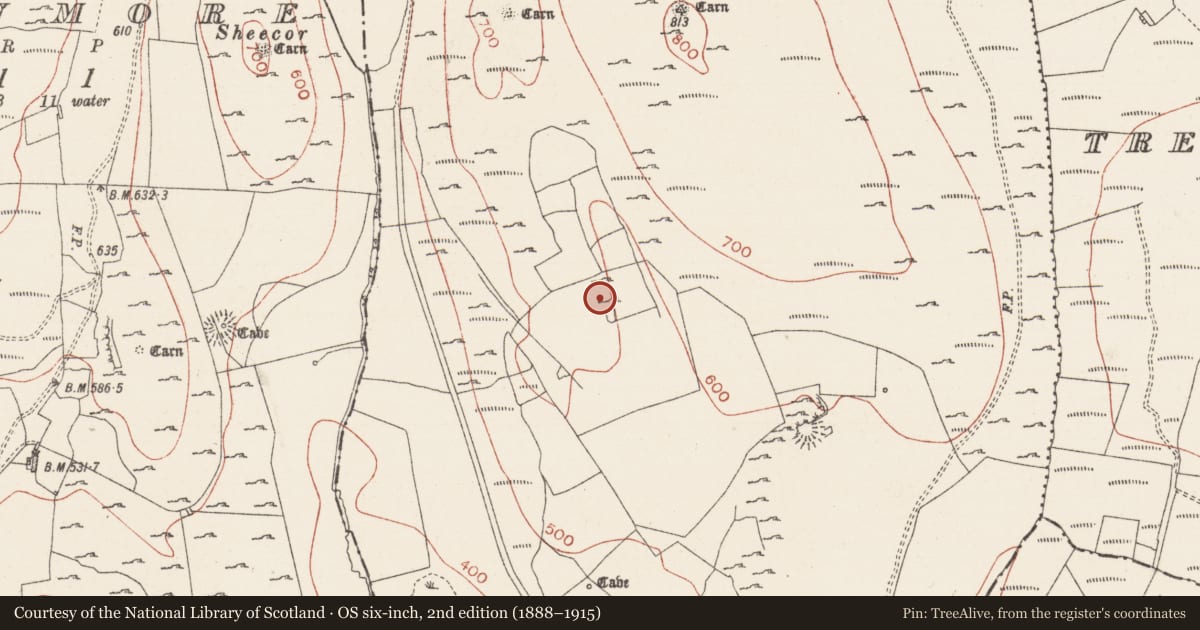
On a narrow shelf, on the E-facing slope of a ridge overlooking a narrow upland valley in the Bricklieve Mountains. Remains comprise a cluster of at least six small rectangular houses (SL040-079002-; SL040-079004-; SL040-079005-; SL040-079006-; SL040-218----), a possible structure (SL040-079004-), associated with a lime kiln (SL040-079008-) and a rectilinear pattern of fields in which traces of ridge and furrow cultivation are visible. The houses are visible as low sod-covered wall footings and are almost identical in size (11m x 4.2m) and plan, typically sub-divided into two or more, usually three, rooms. The core of the settlement consists of a row of three houses. The houses are aligned E-W and arranged in a N-S row, dictated by the contours of the terrace. The most northerly of the three is the largest (14.2m E-W; 4.2m N-S) in the settlement and is separated from the middle house by a gap of 10m. A small rectangular enclosure or garden-plot (17m N-S; 14m E-W) (this is indicated on the 1914 OS 6-inch map) fills most of the intervening space (21m N-S) between the middle house and its neighbour to S. At the NW corner of the rectangular plot is a small sunken subrectangular feature (6m N-S; 2m E-W), possibly the remains of a small shed or lean-to (SL040-079004-). A field-wall extends upslope to W from the NW end of the southern house. Abutting the S side of the wall, 21m W of the house, slightly recessed into the slope, is a ruined limekiln (SL040-079008-). It appears as a small circular area (1.6m N-S; 1.55m E-W) enclosed by a ruined stone wall (Wth 1m; H 0.5m) with an opening (Wth 0.6m) at SE. Another house (SL040-215----) is located 25m to NW of the limekiln, in a natural dip at the top of the ridge. A gap of 9.5m separates the southern house of the cluster of three houses from a rectangular field (27m N-S; 10-2m E-W) subdivided into two roughly equal plots. From here the terrace swings to SW curving around the 'nose' of the ridge. A sub-rectangular depression may indicate the location of another possible house (SL040-079006-) and beyond this to the SW are the foundations of another house (SL040-79007-) with an associated garden plot (14m NE-SW; 11m NW-SE). Although this is located c. 50m SW of the main cluster (SL040-079002-, Sl0040-079003, SL040-079004-) it is clearly part of the same settlement. To the N of the main cluster of houses, the terrace continues for c. 150m to N ending at a rising slope. It expands in width and has been subdivided into a row of large square fields (c. 30-40m N-S; c. 30-40m E-W) with evidence of cultivation ridges. The settlement is not marked on the 1st ed. OS 6-inch map (surveyed 1837) and appears to have been abandoned by then. While it is impossible to date this settlement a date in the 18th century would not be inconsistent for such remains.
Compiled by: Paul Walsh
Date of upload: 17 January 2012
Nearby in the register
- House - 18th/19th centuryunder 1 mi
- House - 18th/19th centuryunder 1 mi
- Structureunder 1 mi
- House - 18th/19th centuryunder 1 mi
Other entries of the same register within about three miles of this one, by straight line.