Sites and Monuments Record · Ireland
Crannog
Cloonfinlough, County Roscommon, Ireland
The record
- Townland
- Cloonfinlough
- County
- Roscommon
- Country
- Ireland
- First-edition OS map
- Indicated
- Latest-edition OS map
- Crannoge
- Coordinates
- 53.75541, -8.15176
- SMR number
- RO029-052----
Slide toward Today to fade the historical sheet and see the modern map underneath.
David Rumsey Map Collection, Stanford LibrariesDavid Rumsey Map Collection, Stanford LibrariesDavid Rumsey Map Collection, Stanford LibrariesDavid Rumsey Map Collection, Stanford Libraries
4 historical maps cover this location, the earliest the 1790 map "Composite: Ireland." (David Rumsey Map Collection, Stanford Libraries).
Historical maps covering this location
- 1790 · Composite: Ireland. (David Rumsey Map Collection, Stanford Libraries)
- 1811 · Ireland. (David Rumsey Map Collection, Stanford Libraries)
- 1869 · Ireland. (David Rumsey Map Collection, Stanford Libraries)
- 1891 · Ireland 16 (David Rumsey Map Collection, Stanford Libraries)
This record in the National Monuments Service's Historic Environment Viewer ↗
The National Monuments Service's description
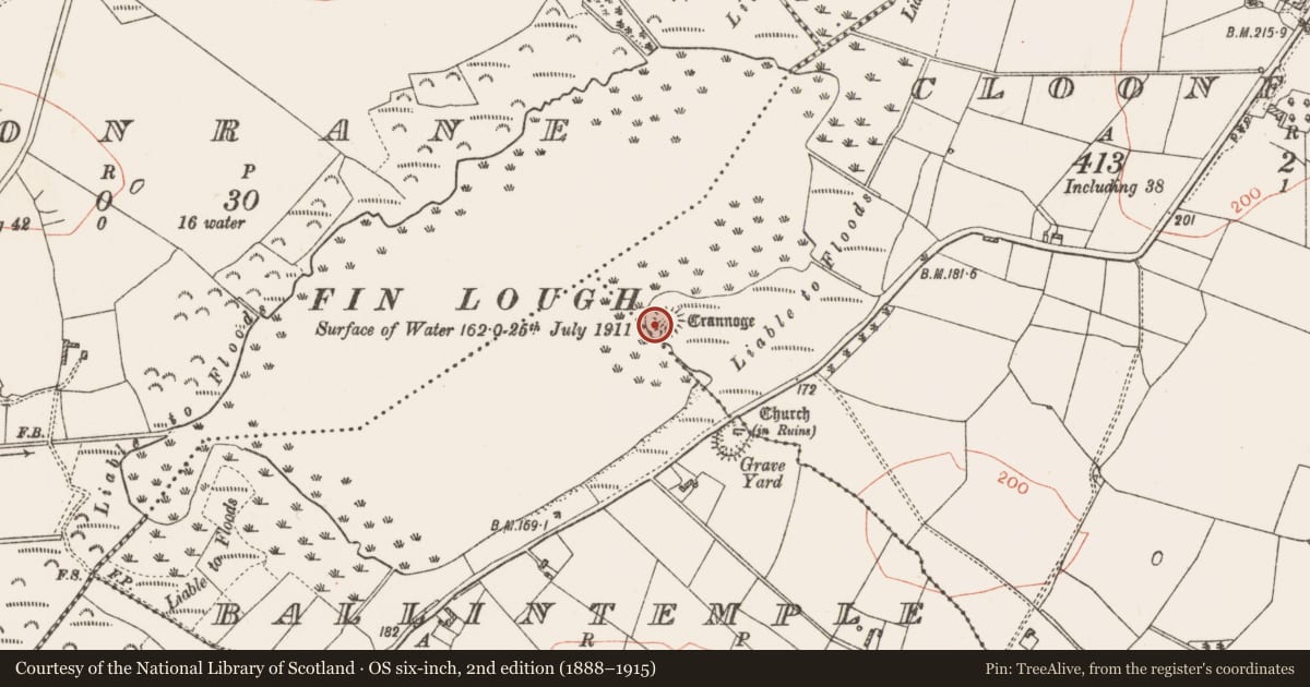
On a low promontory on the SE shore of Fin Lough (dims. c. 900m NE-SW; c. 400m NW-SE). Drainage work conducted 1846-1856 (Whitfield 2001, 61-6) exposed this site for the first time when it was described (Kelly 1850-'3) as a platform of horizontally-laid radiating oaks with a triple oak stockade (diam. c. 40m) and a jetty projecting W. A single trench through two paved levels in the platform recovered a great quantity and variety of bones and artifacts including ringed pins (Fanning 1974-5, 215), and two dug-out canoes were found between the site and the shore.
To-day it is a grass-covered knoll (dims. of top 37m E-W; 15m N-S; dims of base 41m E-W: 20m N-S; H 1m) with an uneven, stony upper surface and a low bank (Wth 3.6m; H 0.3-0.4m) at the perimeter SW-NW. Elsewhere there are shallow quarries around the perimeter. Ballintemple church (RO029-053001-) is c. 150m to the SE on the old shore. (Graves 1858-9,132; Wood-Martin 1886, 233-6)
Compiled by: Michael Moore
Date of upload: 24 August 2010
References
Fanning, T. 1974-5 Some bronze ringed pins from the Irish midlands. Journal of the Old Athlone Society 1(4), 211-18.
Graves, Rev. J. 1858-9 What we learn from Wilde's catalogue of the antiquities in the museum of the Royal Irish Academy. Journal of the Royal Society of Antiquaries of Ireland 5, 110-48.
Kelly, D.H. 1850-53 An artificial island and certain antiquities discovered near Strokestown. Proceedings of the Royal Irish Academy 1C, 208-15.
Wood-Martin, W.G. 1886 (Reprint 1983) The lake dwellings of Ireland: or ancient lacustrine habitations of Erin, commonly called crannogs. Dublin. Hodges, Figgis and Co.
Whitfield, N. 2001 A filigree panel and a coin from an Irish crannog at Alnwick Castle, with an appendix on the discovery of crannogs at Strokestown, Co. Roscommon. Journal of Irish Archaeology 10, 49-72.
Nearby in the register
- Churchunder 1 mi
- Graveyardunder 1 mi
- Ringfort - rathunder 1 mi
- Cross - Churchyard crossunder 1 mi
Other entries of the same register within about three miles of this one, by straight line.