Sites and Monuments Record · Ireland
Church
Summerhill Demesne, County Meath, Ireland
The record
- Townland
- Summerhill Demesne
- County
- Meath
- Country
- Ireland
- First-edition OS map
- Not indicated
- Latest-edition OS map
- Not indicated
- Coordinates
- 53.47045, -6.74641
- SMR number
- ME043-031----
Slide toward Today to fade the historical sheet and see the modern map underneath.
David Rumsey Map Collection, Stanford LibrariesDavid Rumsey Map Collection, Stanford LibrariesDavid Rumsey Map Collection, Stanford LibrariesDavid Rumsey Map Collection, Stanford Libraries
4 historical maps cover this location, the earliest the 1790 map "Composite: Ireland." (David Rumsey Map Collection, Stanford Libraries).
Historical maps covering this location
- 1790 · Composite: Ireland. (David Rumsey Map Collection, Stanford Libraries)
- 1799 · Ireland. (David Rumsey Map Collection, Stanford Libraries)
- 1830 · V.3:11-15:XV. Britisches Reich. C. Kon: Ireland. a. Prov: Leinster. Counties: 1-12 (David Rumsey Map Collection, Stanford Libraries)
- 1891 · Ireland 16 (David Rumsey Map Collection, Stanford Libraries)
This record in the National Monuments Service's Historic Environment Viewer ↗
The National Monuments Service's description
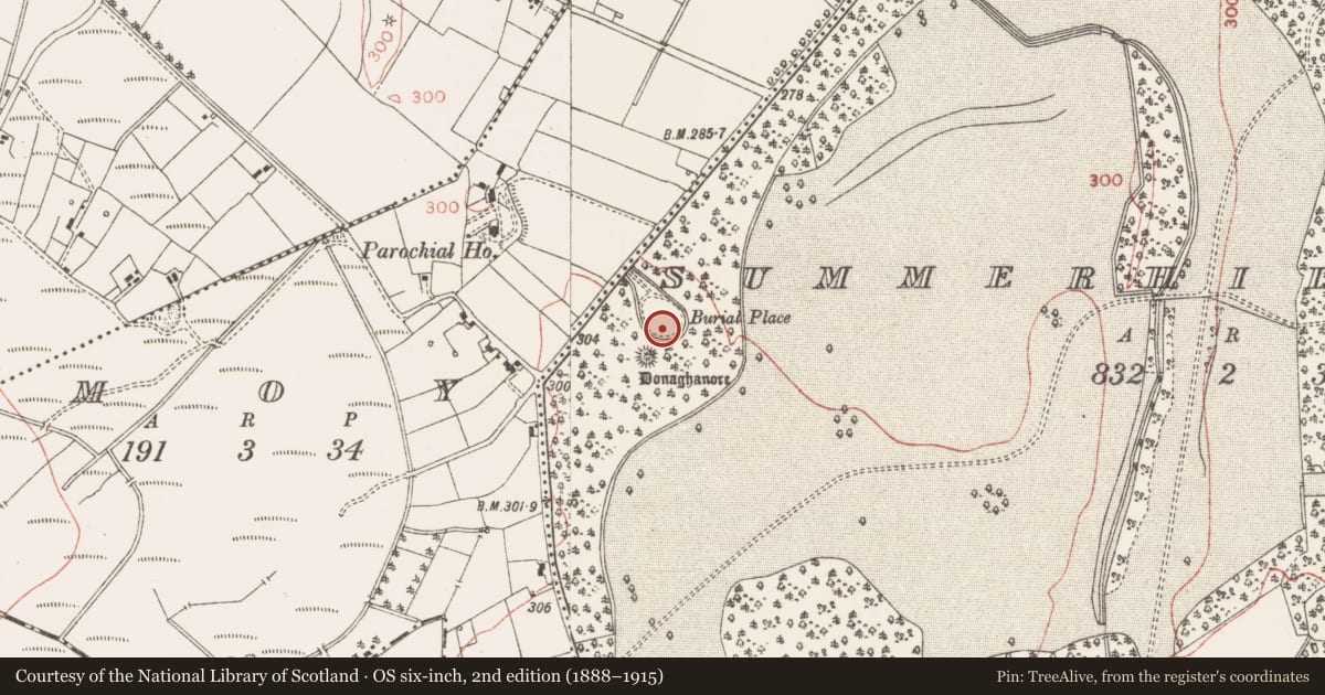
Situated on a NW-facing slope of a prominent hillock, which was known as the Knock. The Civil Survey (1654-5) of Laracor parish records Gerratt Lynch of Knocke owning 500 acres in that townland, which would include the townlands of Summerhill and Moy, and in which there were two castles, a mill and ‘an old chapell’ (Simington 1940, 173). Dopping's Visitation Book (1682-5) lists this church as a chapel-of-ease to Laracor (ME036-044----), and records that the church was built by Bishop Henry Jones and consecrated on 25 July, 1669 (Ellison 1972, 10). There is no visible trace of the church within a circular graveyard (diam. c. 50-55m) defined by a masonry wall N-S-W, but the circuit is not completed W-N where the walls run to a NE-SW public road c. 60m to the NW. Trees grow inside the perimeter, and the headstones in the main date from the mid-18th century to the present.
The headstone (Wth 0.68m; H 0.63m; T 7-9cm) of Mary from Summerhill, dated 1689 (FitzGerald 1910), is leaning forward severely at the centre of the graveyard. The incised legend in roman letters inside a raised frame is crudely executed, the letters becoming smaller towards the bottom. It can be read as:
[ON THE…] DAY OF NOVEMBER IN THE / [YEA]R 1689 THE BODY OF GOOD MARY / [..]EAY OF SVMMERHIL WAS HERE / LAIN SHE (WAS) ONE THAT IN CHARITY / DID ABOVD SINCE FIRST SHE / LAID HER FOOT VPON THE / GROUND. SHE WAS ONE / THAT NEVER DID GRVDGE OF HER FRIEND/ OR WHAT GOD GAVE HER IN THIS WORLD / …EAD SHE WAS ONE THAT NIVER HAD / ….VRS SHE WAS TO HIPAST (?) AND A / ….ANOTHER AMOANVRSE SHE LIVED /…..HER HVSBAND MARTY VIARCANO / …HATH
The above description is derived from the published 'Archaeological Inventory of County Meath' (Dublin: Stationery Office, 1987). In certain instances the entries have been revised and updated in the light of recent research.
Compiled by: Michael Moore
Date of revision: 23 March, 2013
References
Simington, R.C. (ed.) 1940 The Civil survey, AD 1654-1656. Vol. V: county of Meath. Dublin. Irish Manuscripts Commission.
Ellison, Rev. C. C. 1971-5 Bishop Dopping's Visitation Book 1682-5, Ríocht na Mídhe, 5, 1, 28-39; 5, 2, 3-13; 5, 3, 3-11; 5, 4, 98-103; 6, 1, 3-13.
FitzGerald, Lord W. 1910 The Moy Churchyard, Summerhill Demesne, Parish of Laracor. Journal of the Association for the Preservation of the Memorials of the Dead, Ireland, vol. 8, 3. 145-6.
Nearby in the register
Other entries of the same register within about three miles of this one, by straight line.