Sites and Monuments Record · Ireland
Leacht
Inis Gé Theas, County Mayo, Ireland
The record
- Townland
- Inis Gé Theas
- County
- Mayo
- Country
- Ireland
- First-edition OS map
- Not indicated
- Latest-edition OS map
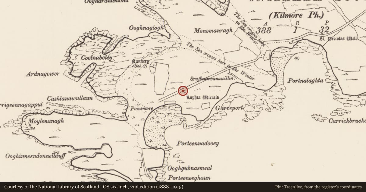
- Laghta Wirraid
- Coordinates
- 54.11282, -10.22344
- SMR number
- MA023-025----
Slide toward Today to fade the historical sheet and see the modern map underneath.
David Rumsey Map Collection, Stanford LibrariesDavid Rumsey Map Collection, Stanford LibrariesDavid Rumsey Map Collection, Stanford LibrariesDavid Rumsey Map Collection, Stanford Libraries
4 historical maps cover this location, the earliest the 1790 map "Composite: Ireland." (David Rumsey Map Collection, Stanford Libraries).
Historical maps covering this location
- 1790 · Composite: Ireland. (David Rumsey Map Collection, Stanford Libraries)
- 1841 · Ireland. (David Rumsey Map Collection, Stanford Libraries)
- 1869 · Ireland. (David Rumsey Map Collection, Stanford Libraries)
- 1891 · Ireland 16 (David Rumsey Map Collection, Stanford Libraries)
This record in the National Monuments Service's Historic Environment Viewer ↗
The National Monuments Service's description
In level, lowlying ground, 60m NE of a small bay called Porteennadooey, on the SE side of Inishkeas South. The grassed-over road that extends E−W across the island is 8m to N.
The nature and date of this monument is uncertain. It is not shown on the 1838 OS 6-inch map, but is named ‘Laghta Wirraid’ (Mhuire, Mary) on the 1921 edition, suggesting that it may have been a leacht, although there is little structural evidence of that visible now. It is evident as a low, subcircular rise (8m N−S; 7m E−W; H 0.3-0.4m), with an uneven sod-covered surface from which occasional stones protrude. A low, partly collapsed roughly constructed L-shaped drystone wall (Wth 0.3-0.5m; H 0.4-0.5m) overlies the S edge; it extends E−W (L 2m) with a short return (L 1.6m) to N from the W end. This is clearly a late feature built on top of the mound.
Relict cultivation ridges on a roughly N−S axis traverse the surrounding area.
Attached images:
MA023-025----_01.JPG Viewed from W
MA023-025----_02.JPG Viewed from N
Compiled by: Jane O’Shaughnessy
Date of upload: 28 July 2022
Nearby in the register
- Religious house - unclassifiedunder 1 mi
- Enclosureunder 1 mi
- House - indeterminate dateunder 1 mi
- Enclosureunder 1 mi
Other entries of the same register within about three miles of this one, by straight line.