Sites and Monuments Record · Ireland
Ritual site - holy well
Knocklong East, County Limerick, Ireland
The record
- Townland
- Knocklong East
- County
- Limerick
- Country
- Ireland
- First-edition OS map
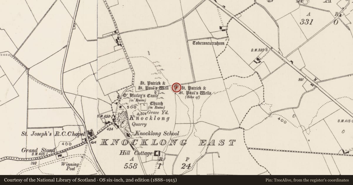
- St. Patricks and St Pauls Wells
- Latest-edition OS map
- St. Patricks and St Pauls Wells
- Coordinates
- 52.42933, -8.40534
- SMR number
- LI041-004008-
Slide toward Today to fade the historical sheet and see the modern map underneath.
David Rumsey Map Collection, Stanford LibrariesDavid Rumsey Map Collection, Stanford LibrariesDavid Rumsey Map Collection, Stanford LibrariesDavid Rumsey Map Collection, Stanford Libraries
4 historical maps cover this location, the earliest the 1790 map "Composite: Ireland." (David Rumsey Map Collection, Stanford Libraries).
Historical maps covering this location
- 1790 · Composite: Ireland. (David Rumsey Map Collection, Stanford Libraries)
- 1882 · Ireland (southern half). (David Rumsey Map Collection, Stanford Libraries)
- 1891 · Ireland 16 (David Rumsey Map Collection, Stanford Libraries)
- 1904 · Sheet 13. (David Rumsey Map Collection, Stanford Libraries)
This record in the National Monuments Service's Historic Environment Viewer ↗
The National Monuments Service's description
Three holy wells dedicated to St. Patrick and St Paul depicted on the 1840 ed. OS 6-inch map. Ó Danachair (1955, 209) recorded the following details about these wells; ‘There are two holy wells, St Patrick's and St Paul's Wells, on the east side of Knocklong hill". OSL - One spring, lined with rough dry-stone, and some old masonry remain. No tradition seems to have survived'. This area is now covered with trees and vegetation making it impossible to verify the location of these holy wells.
Compiled by: Caimin O'Brien
Date of upload: 20 June 2019
References
Ó Danachair, C. 1955 The Holy Wells of County Limerick Journal of the Royal Society of Antiquaries of Ireland 85, 193-217
OSL - Ordnance Survey Letters. Letters written by members of the Ordnance Survey's 'Topographical Department' (T. O'Conor, A. O'Curry, E. Curry, J. O'Donovan and P. O'Keeffe) sent to headquarters from the field (1834-41). MSS in Royal Irish Academy.
Nearby in the register
- Ritual site - holy wellunder 1 mi
- Ritual site - holy wellunder 1 mi
- Mill - unclassifiedunder 1 mi
- Road - road/trackwayunder 1 mi
Other entries of the same register within about three miles of this one, by straight line.