Sites and Monuments Record · Ireland
Kiln - corn-drying
Powerstown East, County Kilkenny, Ireland
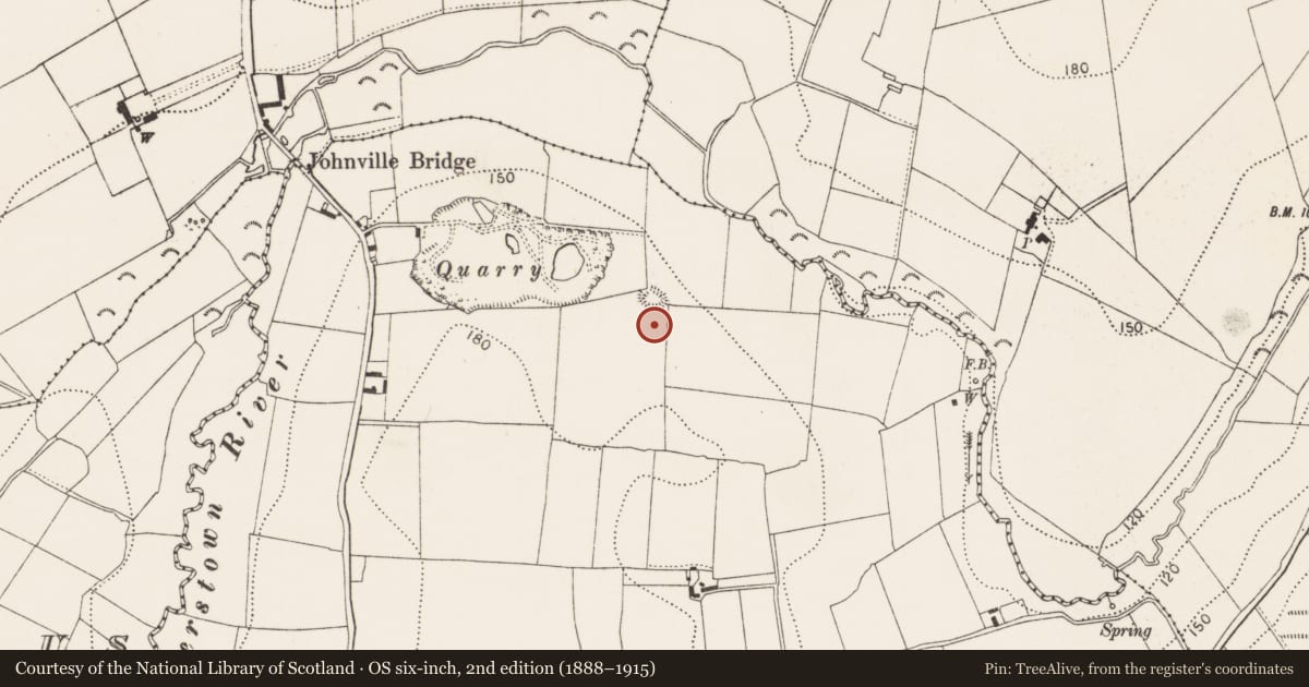
The record
- Townland
- Powerstown East
- County
- Kilkenny
- Country
- Ireland
- First-edition OS map
- Not indicated
- Latest-edition OS map
- Not indicated
- Coordinates
- 52.61382, -7.00445
- SMR number
- KK025-049----
Slide toward Today to fade the historical sheet and see the modern map underneath.
David Rumsey Map Collection, Stanford LibrariesUniversity Library, Vrije Universiteit AmsterdamDavid Rumsey Map Collection, Stanford LibrariesUniversity Library, Vrije Universiteit Amsterdam
4 historical maps cover this location, the earliest the 1790 map "Composite: Ireland." (David Rumsey Map Collection, Stanford Libraries).
Historical maps covering this location
- 1790 · Composite: Ireland. (David Rumsey Map Collection, Stanford Libraries)
- 1891 · Ireland 16 (David Rumsey Map Collection, Stanford Libraries)
- 1904 · Sheet 14, 1904 (University Library, Vrije Universiteit Amsterdam)
- 1911 · Sheet 14, 1911 (University Library, Vrije Universiteit Amsterdam)
This record in the National Monuments Service's Historic Environment Viewer ↗
The National Monuments Service's description
Uncovered during archaeological excavations (04E0392; 04E1263) in 2004 in advance of an extension to Kilcarrig Quarry (McLoughlin 2004). Described by McLoughlin (2007, 226) as a corn-drying kiln, which consisted of a stone-lined regular feature (L 2.05m; max. Wth 1.1m; D 1.29m) with a shallow, narrow irregular cut extending eastwards and a narrow, shallow stone-lined flue-like feature joining the two other elements. The upper fills of the kiln contained extensive evidence for burning, including ash, charcoal and burnt clay (ibid. 227). The main fill of the feature (comprising c. 0.6m of the total depth) comprised a mottled silty clay and contained many charcoal pieces (ibid.). The lower, earliest, fill of the feature contained extensive evidence for burning, with charcoal and burnt clay represented, as well as a plank and two pieces of slag, which were provisionally interpreted as iron slag (ibid.). Two possible post-holes were identified in the eastern portion of the feature (ibid.). The entire feature contained charcoal and animal bone (ibid.). An enclosure (KK025-011----) is located c. 30m to the N.
Compiled by: Jean Farrelly
Date of upload: 28 February 2022
References
McLoughlin, C. 2007 Powerstown East: corn-drying kiln In I. Bennett (ed.), Excavations 2004: summary accounts of archaeological excavations in Ireland, 226-7, No. 921. Dublin. Wordwell.
McLoughlin, C. 2004 Archaeological monitoring, Powerstown East, Co. Kilkenny. Licence: 04E0392. Stafford McLoughlin Archaeology. Unpublished report submitted to the National Monuments Service.
McLoughlin, C. 2004 Preliminary report on archaeological excavation at Powerstown East, County Kilkenny. Licence: 04E1263. Stafford McLoughlin Archaeology. Unpublished report submitted to the National Monuments Service.
Nearby in the register
- Enclosureunder 1 mi
- Enclosureunder 1 mi
- Moated siteunder 1 mi
- Enclosureunder 1 mi
Other entries of the same register within about three miles of this one, by straight line.