Sites and Monuments Record · Ireland
Bawn
Castlewarren, County Kilkenny, Ireland
The record
- Townland
- Castlewarren
- County
- Kilkenny
- Country
- Ireland
- First-edition OS map
- Hachured
- Latest-edition OS map
- Hachured
- Coordinates
- 52.70437, -7.11589
- SMR number
- KK015-014001-
Slide toward Today to fade the historical sheet and see the modern map underneath.
David Rumsey Map Collection, Stanford LibrariesDavid Rumsey Map Collection, Stanford LibrariesDavid Rumsey Map Collection, Stanford LibrariesDavid Rumsey Map Collection, Stanford Libraries
4 historical maps cover this location, the earliest the 1790 map "Composite: Ireland." (David Rumsey Map Collection, Stanford Libraries).
Historical maps covering this location
- 1790 · Composite: Ireland. (David Rumsey Map Collection, Stanford Libraries)
- 1811 · Ireland. (David Rumsey Map Collection, Stanford Libraries)
- 1869 · Ireland. (David Rumsey Map Collection, Stanford Libraries)
- 1891 · Ireland 16 (David Rumsey Map Collection, Stanford Libraries)
This record in the National Monuments Service's Historic Environment Viewer ↗
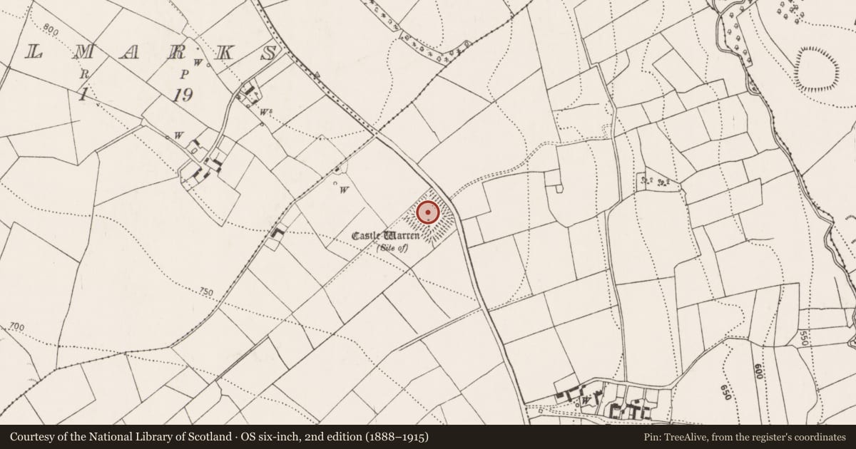
The National Monuments Service's description
Completely enclosed by marshy ground, in an area of extremely poor, peaty soil. Ground rises slightly immediately to the NE. Excellent long-range visibility to SW, down the valley. Surface supply of water. The 1st (1839) ed. and later revised ed. 6-inch OS map indicate the site of a Castle Warren (KK015-014002-) in the interior. Roughly rectangular area (dims. 50m NE-SW, 39m NW-SE) enclosed by a bank (Wth 6m; int. H 0.7m; ext. H 0.9m), fosse (Wth 8m; D 2m) and outer bank (Wth 8m; int. H 2m; ext. H 2m). The fosse and outer bank are best preserved on the SE and SW sides. On the NW side the fosse and outer bank have been truncated by a modern track. On the NE side the outer bank is incorporated into a field fence which is adjacent to a road. In the S quadrant there are traces of buildings (KK015-014003-) running along the SE and SW side of the interior, one of which is larger than the others and may be the remains of Castle Warren. At the W angle there are traces of another building (KK015-015004-). There is a natural spring in the NE quadrant.
Compiled by: Jean Farrelly
Date of upload: 24 February 2016
Nearby in the register
- Castle - unclassifiedunder 1 mi
- Buildingunder 1 mi
- Buildingunder 1 mi
- Moated siteunder 1 mi
Other entries of the same register within about three miles of this one, by straight line.