Sites and Monuments Record · Ireland
Castle - unclassified
Kilmademoge, County Kilkenny, Ireland
The record
- Townland
- Kilmademoge
- County
- Kilkenny
- Country
- Ireland
- First-edition OS map
- Not indicated
- Latest-edition OS map
- Not indicated
- Coordinates
- 52.71351, -7.24713
- SMR number
- KK014-098----
Slide toward Today to fade the historical sheet and see the modern map underneath.
David Rumsey Map Collection, Stanford LibrariesDavid Rumsey Map Collection, Stanford LibrariesDavid Rumsey Map Collection, Stanford LibrariesDavid Rumsey Map Collection, Stanford Libraries
4 historical maps cover this location, the earliest the 1790 map "Composite: Ireland." (David Rumsey Map Collection, Stanford Libraries).
Historical maps covering this location
- 1790 · Composite: Ireland. (David Rumsey Map Collection, Stanford Libraries)
- 1811 · Ireland. (David Rumsey Map Collection, Stanford Libraries)
- 1869 · Ireland. (David Rumsey Map Collection, Stanford Libraries)
- 1891 · Ireland 16 (David Rumsey Map Collection, Stanford Libraries)
This record in the National Monuments Service's Historic Environment Viewer ↗
The National Monuments Service's description
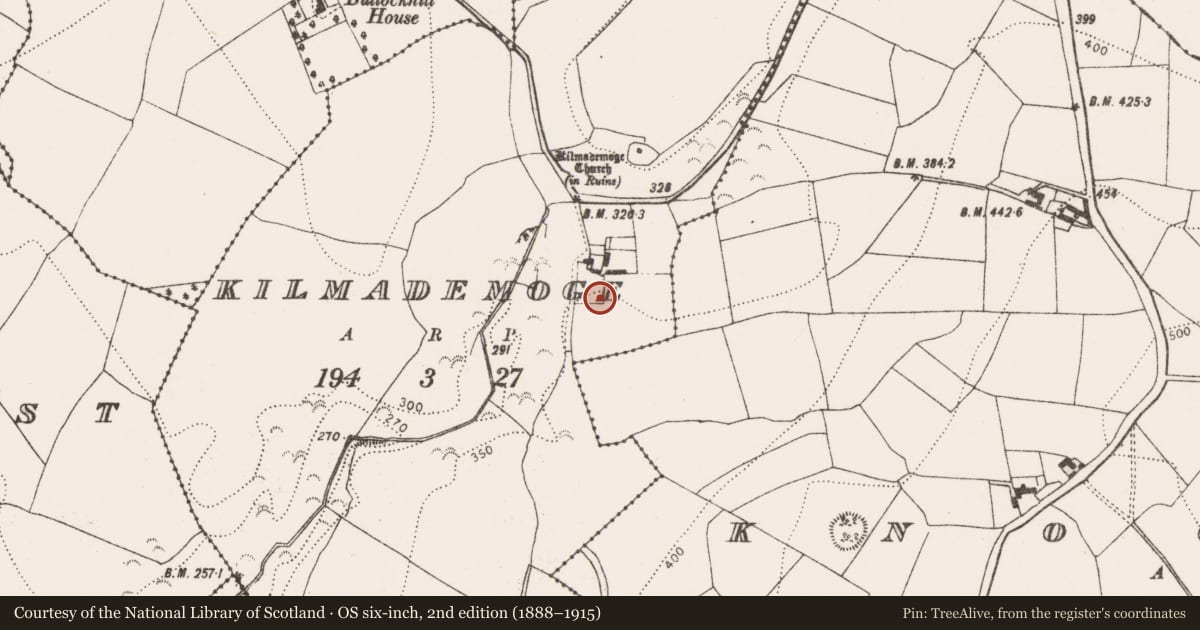
Castle indicated on the Down Survey (1655-6) parish map of ‘Killmidimog’ (Hibernia Regnum, courtesy of Trinity College Dublin). In the terrier accompanying the map, the proprietor of ‘Killmodimoge’ in 1640 are listed as ‘Garrett Blanchvile I[rish] Pa[pist]’ and properties in the townland are listed as, ‘a little Round Castle with a Bawne and some Cabbins’ (ibid.). According to Carrigan (1905, vol. 3, 463), ‘Kilmodimogue Castle stood a few hundred yards south of the church [KK014-042001-], in the haggard of the now deserted farmstead of the Codys…Not a stone or a trace of it now remains’. The precise location of the castle in the vicinity of the farm S of the church is unknown, though it possibly occupied the slightly higher ground to the S of the farm.
See attached:
KK014-090----_01 Extract from Down Survey (1655-6) parish map of ‘Killmodimoge ‘
Compiled by: Jean Farrelly
Date of upload: 16 June 2020
References
Carrigan, Rev. W. 1905 (Reprint 1981) The history and antiquities of the diocese of Ossory, 4 vols. Kilkenny. Roberts Books and Wellbrook Press.
Nearby in the register
- Water mill - horizontal-wheeledunder 1 mi
- Graveyardunder 1 mi
- Churchunder 1 mi
- Enclosureunder 1 mi
Other entries of the same register within about three miles of this one, by straight line.