Sites and Monuments Record · Ireland
Castle - tower house
Ballycuddihy (Galmoy By.)), County Kilkenny, Ireland
The record
- Townland
- Ballycuddihy (Galmoy By.))
- County
- Kilkenny
- Country
- Ireland
- First-edition OS map
- Castle
- Latest-edition OS map
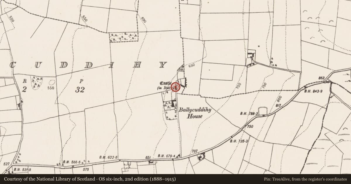
- Castle (in Ruins)
- Coordinates
- 52.75121, -7.52232
- SMR number
- KK008-101----
Slide toward Today to fade the historical sheet and see the modern map underneath.
David Rumsey Map Collection, Stanford LibrariesDavid Rumsey Map Collection, Stanford LibrariesDavid Rumsey Map Collection, Stanford LibrariesDavid Rumsey Map Collection, Stanford Libraries
4 historical maps cover this location, the earliest the 1790 map "Composite: Ireland." (David Rumsey Map Collection, Stanford Libraries).
Historical maps covering this location
- 1790 · Composite: Ireland. (David Rumsey Map Collection, Stanford Libraries)
- 1868 · 4. Ireland. (David Rumsey Map Collection, Stanford Libraries)
- 1869 · Ireland. (David Rumsey Map Collection, Stanford Libraries)
- 1891 · Ireland 16 (David Rumsey Map Collection, Stanford Libraries)
This record in the National Monuments Service's Historic Environment Viewer ↗
The National Monuments Service's description
At a break in slope in a valley, in rolling grassland. The views are fair to good, though somewhat overlooked to the E by high ground. A three-storey rectangular tower house (ext. dims. 7m N-S; 4.8m E-W; wall T 1.04-1.22m) built of roughly coursed limestone rubble with dressed quoins. There is a basal-plinth and slight base-batter (H 1.63m; Wth 0.12m) at the NW angle, otherwise no base-batter. It was entered at ground-floor level through a central pointed doorway in the E wall. The small ground-floor chamber (dims. 4.57m N-S; 2.58m E-W) was lit by two loops, one in the centre of the S wall and one S of centre in the W wall, both blocked. There is a wall cupboard at the S end of the E wall and there are two wall cupboards in the W wall, one at either end of the wall. There is a large embrasure at the E end of the N wall which may have had a loop, now blocked, and a wall cupboard in the E face. There is no stair from the ground floor to first-floor level, presumably it was accessed via a wooden stair/ladder through the wooden floor which was supported on corbels. The stair was in the NE angle of the chamber where there is a flat-headed doorway giving access to a spiral stair which rises in the NE angle of the tower house and gives access to the second floor.
The first floor was lit by a flat-headed single-light window in the centre of the W wall and by a loop in the SW angle. There is a fireplace at the S end of the E wall, the flue of which is carried externally at second-floor level on projecting masonry supported by corbels. There are two wall cupboards, one in the centre of the S wall and one at the N end of the W wall. Above the first-floor and below the pointed vault, there appears to have been a loft, resting on corbels on the N and S walls. Also at first-floor level and accessed from the spiral stair is a garderobe chamber (dims. 2.1m x 0.8m; H 2-2.05m) which runs along the N wall. The garderobe (dims. 0.56m x 0.35m) is at the end of this rectangular chamber and exits from a chute at the W end of the N wall which is now blocked up. The chamber is lit by a loop with slop stone beneath it and there is a small wall cupboard at the rear of the garderobe, the back of which has been broken through.
The second floor was 0lit by a round-headed single-light window in the S wall and by ogee-headed single-lights in the N, E and W walls. The N window has a slop-stone beneath the sill. There is no fireplace which suggests this chamber was probably heated by a brazier. A flat-headed doorway at the N end of the W wall gives access to a stair to the parapet. The stair is covered by a caphouse, with the doorway facing onto the W wall-walk. Only the lower courses of the battlements survive. The wall-walk and roof rested on masonry courses which project internally at second-floor level.
On the exterior, projecting from the E wall, are the coping stones of a steeply pitched gable roof. The coping is built into the wall and the lowest coping stone, on both sides, is incorporated into the quoin stone. There is a lot of ivy at second-floor level, however, where visible, the coping does not continue into second-floor level, where it would have reached its apex at or just above the central E window. A flat-headed doorway has been inserted at first-floor level at the N end of the E wall giving access to this level and onto the spiral stair. The internal stair arrangement at first-floor level appears to have been altered slightly during this phase. Broken out masonry in the external wall face below this doorway is evidence of a stair, indicated on the 25-inch OS map, which was fixed into the wall to give access to this doorway.
Against the S wall there is also the scar of a much later two-storey outbuilding with a shallow pitched roof, the apex of which reached first-floor level. This building, with its internal concrete rendering and concrete floor, was removed c. 1980. There are also footings of a low building which had been added to the N wall and is clearly indicated on the 25-inch OS map. It was noted in the 1980s (OPW files) that an oven and range had been inserted into the ground-floor embrasure in the N wall, now since removed, but disturbed masonry visible in the external N wall of the tower house may indicate where a later flue related to this range was inserted.
Compiled by: Jean Farrelly
Date of upload: 4 September 2018
Nearby in the register
Other entries of the same register within about three miles of this one, by straight line.