Sites and Monuments Record · Ireland
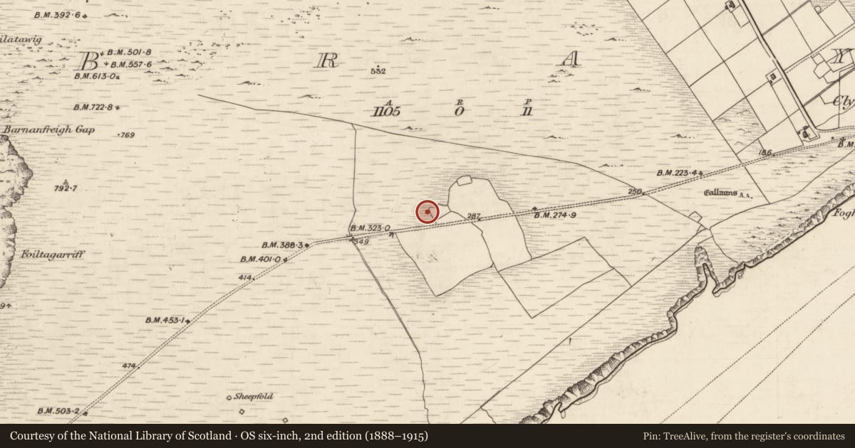
House - medieval
Bray, County Kerry, Ireland
The record
- Townland
- Bray
- County
- Kerry
- Country
- Ireland
- First-edition OS map
- NULL
- Latest-edition OS map
- Not indicated
- Coordinates
- 51.89058, -10.40993
- SMR number
- KE087-080002-
Slide toward Today to fade the historical sheet and see the modern map underneath.
David Rumsey Map Collection, Stanford LibrariesDavid Rumsey Map Collection, Stanford Libraries
2 historical maps cover this location, the earliest the 1753 map "Mappa geographica Regni Hiberniae" (David Rumsey Map Collection, Stanford Libraries).
Historical maps covering this location
- 1753 · Mappa geographica Regni Hiberniae (David Rumsey Map Collection, Stanford Libraries)
- 1841 · Ireland. (David Rumsey Map Collection, Stanford Libraries)
This record in the National Monuments Service's Historic Environment Viewer ↗
The National Monuments Service's description
On the SE-facing slopes of Bray Head on Valencia Island. This is described by O'Sullivan and Sheehan (1996, 208, no. 707) as the 'earth and stone foundations' of a house. This was archaeologically excavated in 1994 (Hayden 1995a, 43) revealing the remains of a rectangular stone-built house (6.7m N-S; 3.4m E-W) with an annexe (ext. dims.: 9.5m N-S; 4.5m E-W) to the S. The annexe was excavated in 1995 (Walsh 1996b). Both buildings stood on a platform built up on the S side and cut into the upslope on the N side. The house had two doors in the W wall and one in the E wall. Within the interior a central, unlined hearth and underfloor stone-capped drains were found. During a secondary occupation the house was divided into two rooms, at N (L 2.8m) and S (L 4m), and the hearth was relocated to the N room. The annexe, which was built against the S gable of the house, had clay-bonded stone walls which, when excavated, did not survive above footing level. It comprised of two rooms: Room A (3.5m N-S; 2.5m E-W) at N; Room B (3.5m E-W; 2.5m N-S) at S. A system of sub-floor drains, some of which were stone lined and capped, were channelled through the S wall of Room B. This channel was roofed with large lintels and was similar to that in the S wall of the main house. Room B in the annexe was open to the E. A deep pit (D 0.5m), of uncertain function, was situated outside the E side of Room B. Following abandonment the building was demolished. Secondary occupation deposits from the house yielded a fragment of an iron knife and a sherd of 14-17th century Low Countries Redware. A sample of burnt material from the primary floor of the house yielded a calibrated radiocarbon date of between 1410 and 1620 AD (GrN21032). This is one of six houses (see KE087-080003-; KE087-080004-; KE087-080005-; KE087-080006-; KE087-080007-) which make up a 'street' of house-platforms that extend for c. 70m along an E-W line (Mitchell et al. n.d.). These houses may have formed part of a village settlement called 'Crompeol' which is shown on a map of Valencia, in the Carew MS., dating to c. 1600 AD. (Hayden 1994b, 1-12; Hayden 1995a; Walsh 1996b; Mitchell et al. n.d.; O'Sullivan and Sheehan 1996, 208, no. 707)
The above description is derived from the published 'Archaeological Inventory of County Kerry. Volume I: South-West Kerry' (Dublin: Stationery Office, 2009). In certain instances the entries have been revised and updated in the light of recent research.
Date of upload: 30 May 2011
Nearby in the register
- House - medievalunder 1 mi
- House - medievalunder 1 mi
- House - medievalunder 1 mi
- House - medievalunder 1 mi
Other entries of the same register within about three miles of this one, by straight line.