Sites and Monuments Record · Ireland
Building
Eglish, County Galway, Ireland
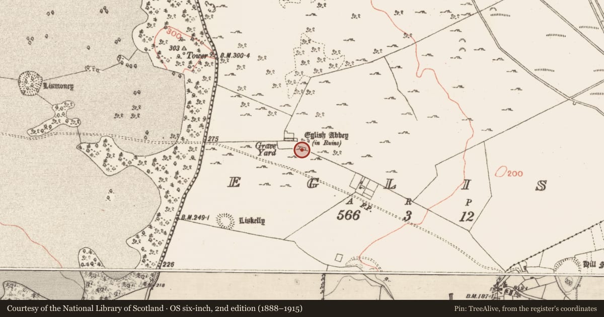
The record
- Townland
- Eglish
- County
- Galway
- Country
- Ireland
- First-edition OS map
- Indicated
- Latest-edition OS map
- Indicated
- Coordinates
- 53.39771, -8.28119
- SMR number
- GA061-080003-
Slide toward Today to fade the historical sheet and see the modern map underneath.
David Rumsey Map Collection, Stanford LibrariesDavid Rumsey Map Collection, Stanford LibrariesDavid Rumsey Map Collection, Stanford LibrariesDavid Rumsey Map Collection, Stanford Libraries
4 historical maps cover this location, the earliest the 1790 map "Composite: Ireland." (David Rumsey Map Collection, Stanford Libraries).
Historical maps covering this location
- 1790 · Composite: Ireland. (David Rumsey Map Collection, Stanford Libraries)
- 1857 · Ireland (David Rumsey Map Collection, Stanford Libraries)
- 1869 · Ireland. (David Rumsey Map Collection, Stanford Libraries)
- 1891 · Ireland 16 (David Rumsey Map Collection, Stanford Libraries)
This record in the National Monuments Service's Historic Environment Viewer ↗
The National Monuments Service's description
At S end of a long low hill in pastureland, it stands on N side of a rectangular graveyard (GA061-080002-). This medieval monastery, the earliest documentary record of which occurs in 1436-7, appears to have been founded as a Carmelite house, possibly becoming Franciscan later (Connellan 1943b, 15-21; Gwynn and Hadcock 1970, 280, 289). What is visible are the partially ivy-clad remains of a church in fair condition, along with the poorly preserved remains of a cloister garth and a domestic wing. Of the rectangular church (E-W; L 26m, Wth 6.5m), most of its walls still stand, albeit partially rebuilt and punctuated by a number of modern gaps. The original doorway, now robbed out and blocked up, was in W gable: it contains a water font in S jamb of its embrasure. The W jamb of another doorway is also visible in the masonry towards W end of N wall: it probably gave access to the cloister area. The partially blocked embrasure of a small robbed-out window is visible at E end of S wall. Connellan (ibid. 20) mentions a 'sedilia ... to the right [W] of this window' of which no definite trace survives. A large ragged ope marks the site of E window 'where, forty years ago, stood a fine spacious window of four lights ... in the pointed style and of cut stone' (ibid.). A rectangular cloister area (E-W; L 20m, Wth 13.7m) abuts the church to N with a small annexe or cell (L 7m, Wth 5m) at its NW corner. Little survives of the claustral area. It was flanked along E side by a two-storey domestic range, the N and E walls of which still stand. Fragments of another building are also evident extending to S from SE corner of the annexe; possibly part of a W range. The only surviving architectural features are two single-light ogee-headed windows in E range. A number of modern burial vaults and graves now occupy the church. Some 20m to SE stands another building (GA061-080003-), known locally as 'Teampall Maol' (ibid., 21). It consists of a partially ivy-clad rectangular building (WNW-ESE; L 16.5m, Wth 5.5m), in fair condition, with a pointed arch doorway in W wall and robbed windows in E and S walls. A number of old grassed-over field walls surround the friary, particularly to SE, S and W. These included the foundations of a large rectangular enclosure (E-W 50m, N-S 15m) (GA061-080004-) to WSW but this has recently been levelled during land reclamation. (O'Flanagan 1927, Vol. 1, 117-18)
The above description is derived from the published 'Archaeological Inventory of County Galway Vol. II - North Galway'. Compiled by Olive Alcock, Kathy de hÓra and Paul Gosling (Dublin: Stationery Office, 1999).
Date of upload: 05 August 2010
Nearby in the register
- Graveyardunder 1 mi
- Religious house - Carmelite friarsunder 1 mi
- Enclosureunder 1 mi
- Ringfort - unclassifiedunder 1 mi
Other entries of the same register within about three miles of this one, by straight line.