Sites and Monuments Record · Ireland
Graveslab
Kilgobbin, County Dublin, Ireland
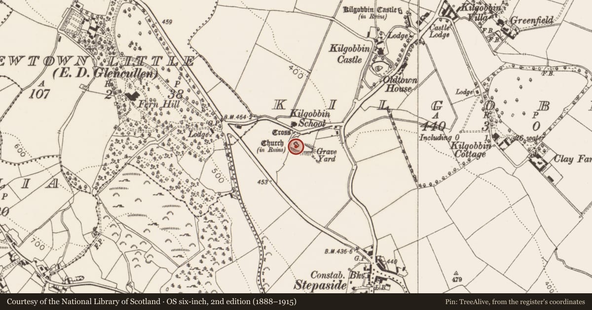
The record
- Townland
- Kilgobbin
- County
- Dublin
- Country
- Ireland
- First-edition OS map
- Not indicated
- Latest-edition OS map
- Not indicated
- Coordinates
- 53.25617, -6.21771
- SMR number
- DU025-016004-
Slide toward Today to fade the historical sheet and see the modern map underneath.
David Rumsey Map Collection, Stanford LibrariesDavid Rumsey Map Collection, Stanford LibrariesDavid Rumsey Map Collection, Stanford LibrariesDavid Rumsey Map Collection, Stanford Libraries
4 historical maps cover this location, the earliest the 1799 map "Ireland." (David Rumsey Map Collection, Stanford Libraries).
Historical maps covering this location
- 1799 · Ireland. (David Rumsey Map Collection, Stanford Libraries)
- 1811 · Ireland. (David Rumsey Map Collection, Stanford Libraries)
- 1841 · Ireland. (David Rumsey Map Collection, Stanford Libraries)
- 1891 · Ireland 16 (David Rumsey Map Collection, Stanford Libraries)
This record in the National Monuments Service's Historic Environment Viewer ↗
The National Monuments Service's description
Attached to the S face of the N wall of Kilgobbin church (DU025-016001-) above the saltire cross-slab (DU025-016003-) there is a fragment of a graveslab found during restoration work in the graveyard (DU025-016002-). It is a small granite fragment (L 0.33m, Wth 0.2m, T 0.13m) which bears part of a shallow cup-mark with three concentric circles below (Ó hÉailidhe 1984, 142).
Discovered in 1983 when Dublin County Council undertook conservation works at Kilgobbin church and graveyard. Graveslab fragment (stone b) described by Ó hÉailidhe (1984, 142) as follows; 'Fragment of a grave slab of the Early Christian period found lying in the graveyard by the stone mason, Mr William Long, who saw the lines on it and put it aside for examination. It is only a small fragment, measuring 33cm by 20cm by 13cm thick, and is also of granite. It bears part of a shallow cupmark and set of three concentric circles. This piece also belongs to the Rathdown group of slabs, on which the cup mark and concentric circles are on of the commonest motifs'.
To see a 3D model of this graveslab, visit: https://skfb.ly/oEFts
Compiled by: Geraldine Stout and Padraig Clancy
Revised by: Caimin O'Brien
Date of revised upload: 31 March 2023
References
Ó hÉailidhe, P. 1984 Decorated stones at Kilgobbin, county Dublin. Journal of the Royal Society of Antiquaries of Ireland 114, 142-4.
Anon. 1900 Excursion to Tully, Rathmichael, Kiltiernan and other places in south County Dublin. Journal of the Royal Society of Antiquaries of Ireland 30, 180-92.
Turner, K. 1983 If you seek monuments: a guide to the antiquities of the barony of Rathdown. Rathmichael Historical Society.
Anon. 1900 Proceedings. Journal of the Royal Society of Antiquaries of Ireland, vol. 10, no. 4, 388-450.
Nearby in the register
- Cross-slabunder 1 mi
- Churchunder 1 mi
- Graveslabunder 1 mi
- Architectural fragmentunder 1 mi
Other entries of the same register within about three miles of this one, by straight line.